
Beskid Targanicki is a climb of 4.9 kilometers (category 3). The climb finishes at 555 m above sea level. It is located in Kozubnik, województwo śląskie, Polska. The average gradient is 4.0% with a maximum of 15.5%. The climb has 197 meters of elevation gain.
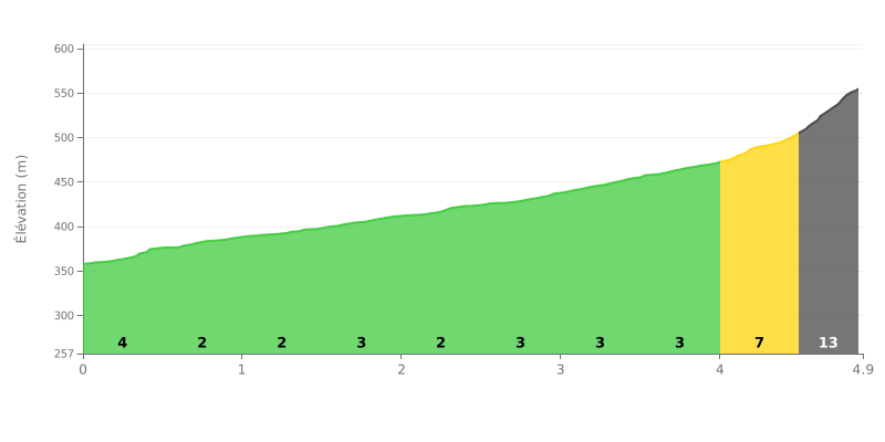
Difficulty analysis: This 4.9 km climb gaining 197 m of elevation averages a 4% gradient, which puts it in the 3rd category. The first three kilometers are relatively rolling, with gradients between 2% and 4%, which lets you find a good rhythm. The real challenge comes in the final section: the 4.0-4.5 km stretch climbs at 7%, then the 4.5-4.9 km stretch hits 13% over 369 m, where much of the elevation gain is concentrated.
Tips for managing your effort:
1. Pace yourself from the start. Between 0.0 and 3.5 km, hold a steady rhythm on gradients of 2 to 4% so you reach the final section with some energy left.
2. Make the most of the easier sections. The 1.0-1.5 km and 2.0-2.5 km stretches, at 2%, are ideal for recovering and picking up your cadence.
3. Prepare for the final push. Shift into a light enough gear before the 4.0 km mark and keep a smooth, steady cadence on the 13% section (4.5-4.9 km) rather than mashing the pedals.
The climb is mainly tackled for its gradient. One rider describes it as a podjazd ciężki, meaning a hard effort, on a sztywniutki road, very steep, that really puts your legs to the test. He finds it particularly well suited to road bikes.
Those who have ridden it recommend stopping at the top or halfway up to take in the great views. It's the point that comes up most often in riders' accounts.
As for the route, one rider points out the trailhead where the paths leave for Kocierz and Trzonka, and the option of linking up with the Porąbka dam. He describes the green trail to Kocierz as pleasant but not very scenic.
4.9 km • 197 m D+
VAM: average climbing speed, based on elevation gain


Join thousands of cycling fans! Plan your rides, record your performance, track your progress and discover the finest climbs.
Live climb profile to pace your effort all the way to the top.


Within 20 km