
Perevel Kamin-Klevka (Rakhivskyi) is a climb of 15.1 kilometers (category 1). The climb finishes at 1,016 m above sea level. It is located in Kosivska Poliana, Закарпатська область, Україна. The average gradient is 4.7% with a maximum of 13%. The climb has 708 meters of elevation gain.
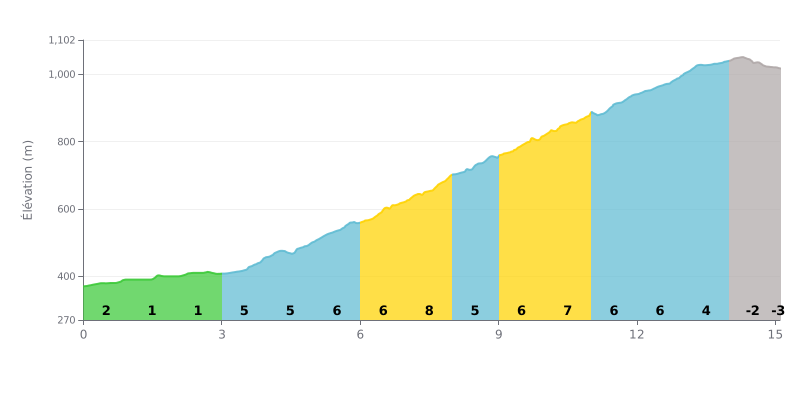
Difficulty analysis: At 15.1 km with an average gradient of 4.7%, this 1st category climb demands sustained effort over the duration. The first three kilometres, between 1% and 2%, let you ease into it, then the climb settles into a steady rhythm between km 3.0 and km 13.0, with gradients of 4% to 8%. The hardest section comes at km 7.0-8.0 at 8%, followed by stretches at 6% and 7% up to km 12.0. The km 14.0-15.0 section, a slight descent at -2%, marks the end of the difficulty.
Tips for pacing the effort:
1. Save your legs at the start On the 1% and 2% slopes from km 0.0 to km 3.0, ride at a strong but controlled pace so you reach the foot of the steep part with something in the tank.
2. Handling the 8% section from km 7.0 to km 8.0 Shift to an easier gear, stay in the saddle if you can, and prioritise a smooth cadence over mashing the pedals.
3. Holding a steady effort from km 8.0 to km 13.0 On the 6% and 7% stretches, aim for a steady power output and keep drinking regularly, because fatigue builds up before the top.
You can ride or drive up Lysa Hora, and the two ways are very different. On foot, the direct trail from Rakhiv takes about two hours for the fastest hikers, and more like three or four for others, over more than 7 km. It climbs almost nonstop. People who've taken it say it's slippery, with clay and leaves, and hard to follow in places. One cyclist recommends the shortcut via Burkut, because the direct route is brutal when you're not so young anymore.
The paved road is longer, roughly double the time. It climbs through steep switchbacks, and reports say it takes one to two hours by car to reach the top. Near the end, the road turns into a mountain track with rocks and potholes. Plan to take it easy, and some people had to finish on foot for nearly 500 m. The summit sign only shows up as you get close to the top. The descent takes 40 to 50 minutes. You need a suitable vehicle, a 4x4 in good weather according to several people, though a scooter can also make it.
At the top, the view goes a long way: Rakhiv down below, the peaks of Petros and Hoverla, and, when the clouds are below you, a sea of clouds. Several people recommend coming up early for the sunrises and the morning mist, while others talk about sunsets. There are sheep and shepherds on the grass, a swing with a view that's worth the trip, and a cheese dairy where you can taste brynza and other cheeses, including a cow's milk cheese with blueberries that one visitor calls the best of their life. To visit the shepherds, you need to call the owner in advance.
The place is quiet. One person found it almost deserted, with mostly locals who had come to their dachas. You can sleep on site in small, cozy houses, with toilets, a shower and a kitchen available. Some of the buildings and the restaurant aren't finished yet, which is a result of the current situation in the country. One visitor came through in winter and says the landscape is completely different then. For your legs, several people warn that you'll feel them the next day.
15.1 km • 708 m D+
VAM: average climbing speed, based on elevation gain


Join thousands of cycling fans! Plan your rides, record your performance, track your progress and discover the finest climbs.
Live climb profile to pace your effort all the way to the top.


Other climbs to Perevel Kamin-Klevka (Rakhivskyi)