
Muktinath Mandir is a climb of 14.2 kilometers (hors catégorie). Muktinath Mandir tops out at 3,778 m above sea level. It is located in Kāgbeni, गण्डकी प्रदेश, नेपाल. The average gradient is 7.1% with a maximum of 16.3%. The climb has 1006 meters of elevation gain.
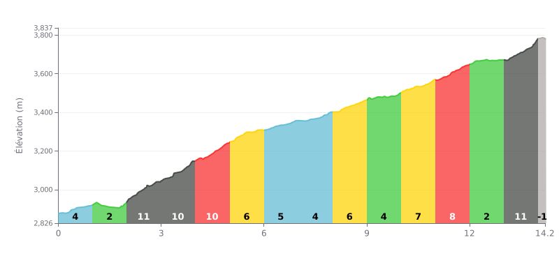
Difficulty analysis: This HC climb has a very uneven profile. The difficulty lies in the succession of very steep sections (three stretches at 10-11%) with short recovery stretches that are not enough for full recovery, especially the 1% kilometre and the final descent. The last kilometre at 11% makes for a particularly demanding finish.
Tips for pacing yourself:
1. Managing the changes in gradient: Anticipate the changes in gradient. Avoid going into the red on the 10-11% sections (KM 2-5 and 13) and use the moderate sections (KM 5-10) to find a steady breathing rhythm again.
2. Controlling the start: The start is deceptive (5% then 1%). Resist the temptation to go out too hard before the brutal run of 11% gradients that starts at the 2nd kilometre.
3. Saving something for the finish: Keep some energy in reserve for the last kilometre, which is the steepest (11%). The slight descent just before (KM 12-13) is the ideal place to recover without losing too much speed.
For cyclists who have tackled the steep roads leading to the Muktinath temple, the experience is described as an epic adventure, a test of both body and mind. The road from Pokhara or Jomsom is often very tough, with long unpaved stretches, potholes, loose rock and hairpin bends along dizzying drop-offs. This ride, called "one of the most dangerous" by some, is an integral part of the challenge and of the pride in reaching this holy site perched at over 3,700 meters.
The reward, however, is worth every pedal stroke. Riders agree on the breathtaking scenery: panoramic views of the Annapurna and Dhaulagiri ranges, the deep gorges of the Kali Gandaki river, and the unique atmosphere of the cold desert of Mustang. Arriving at the temple, after a final climb on foot or by horse from the car park, brings a deep sense of peace and accomplishment.
At the top, the atmosphere is one of a kind, a blend of religious fervor and natural serenity. Cyclists describe the emotion of discovering this place that is sacred to both Hindus and Buddhists, with its 108 water spouts of icy water where pilgrims purify themselves, and the eternal flame of Jwala Mai. Despite the sometimes large crowds, the place gives off a soothing spiritual energy, enhanced by the silence of the surrounding mountains.
Riders stress that it is crucial to prepare for the effects of altitude (altitude sickness, lack of oxygen) and to choose the right season (spring and autumn are ideal). While the trip is demanding, it leaves a lasting mark, well summed up by one cyclist: "The hardest roads often lead to the most beautiful destinations".
14.2 km • 1006 m D+
VAM: average climbing speed, based on elevation gain


Join thousands of cycling fans! Plan your rides, record your performance, track your progress and discover the finest climbs.
Live climb profile to pace your effort all the way to the top.

