
Gunung Lingga is a climb of 3.7 kilometers (category 1). The climb finishes at 551 m above sea level. It is located in Kawitan, Jawa Barat, Indonesia. The average gradient is 6.7% with a maximum of 12.4%. The climb has 251 meters of elevation gain.
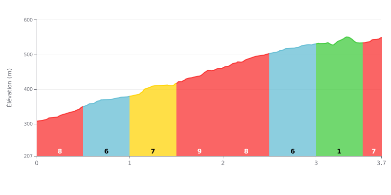
Difficulty breakdown: This 3.7 km climb gains 251 m of elevation at an average gradient of 6.7%, which puts it in Category 1. Most of the work is concentrated between km 0.0 and km 2.5, where the gradient bounces between 6% and 9%, with a stretch at 9% between km 1.5 and km 2.0. The section from km 3.0 to km 3.5, at just 1%, is a real breather before the final 217 meters at 7%. It's a demanding climb, short but steady, that wears your legs down gradually.
Tips for pacing the climb:
1. Pace yourself from the start. The first 500 m at 8% tempt you to go out too hard, so keep a steady cadence and a controlled effort right from the bottom of the col.
2. Make the most of the false flat. Between km 3.0 and km 3.5, the 1% gradient gives you a chance to recover, drink, and bring your cadence back up before the final section.
3. Save something for the finish. On the last stretch, from km 3.5 to km 3.7 at 7%, you can get out of the saddle and empty the tank.
A cyclist who climbed Gunung Lingga describes a place that is beautiful and cool: "Karna tempat ini indah dan sejuk", meaning "because this place is beautiful and cool".
Another testimony comes down to two words, in Sundanese: "Lembur aing", which means "my village". The text does not say whether the author lives at the foot of the climb or is talking about the region in general.
These testimonies are very short. They say nothing about the road, the gradient, the traffic or how hard the climb is.
3.7 km • 251 m D+
VAM: average climbing speed, based on elevation gain


Join thousands of cycling fans! Plan your rides, record your performance, track your progress and discover the finest climbs.
Live climb profile to pace your effort all the way to the top.

