
Przełęcz Hałbowska is a climb of 4.8 kilometers (category 3). The climb finishes at 536 m above sea level. It is located in Kąty, województwo podkarpackie, Polska. The average gradient is 4.8% with a maximum of 7.4%. The climb has 228 meters of elevation gain.
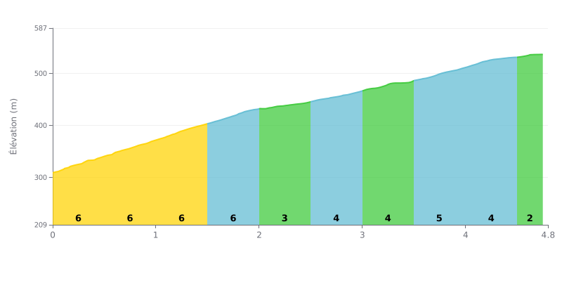
Difficulty breakdown: This 4.8 km climb averages 4.8% over 228 m of elevation gain, which puts it in category 3. The first two kilometres, at 6% between 0.0 and 2.0 km, are the hardest part, so start with restraint. The gradient stays tough between 2.5 and 4.5 km, with sections of 4 to 5%, before easing to 2% on the final stretch (4.5 to 4.8 km). It's a steady climb with no real extended respite.
Pacing tips:
1. Pace your start. Take the first 2 km at 6% with a controlled effort, and don't go out too hard in the first few hundred metres.
2. Recover on the false flat. Use the 3% section (2.0 to 2.5 km) to ease off slightly and settle into a steady rhythm before what comes next.
3. Keep a steady cadence to the top. Between 2.5 and 4.5 km, stay seated with a gear that suits the gradient, then build up gradually on the final 2%.
Only one testimonial so far, and it's very short. A cyclist says they rode half of the Hałbów nature trail and found the switchbacks fun.
The testimonial says nothing about the road surface, traffic, or the scenery.
4.8 km • 228 m D+
VAM: average climbing speed, based on elevation gain


Join thousands of cycling fans! Plan your rides, record your performance, track your progress and discover the finest climbs.
Live climb profile to pace your effort all the way to the top.

