
Bunsuiten is a climb of 8.5 kilometers (hors catégorie). The climb finishes at 685 m above sea level. It is located in Kaihua, 浙江省, 中国. The average gradient is 5.8% with a maximum of 12.8%. The climb has 497 meters of elevation gain.
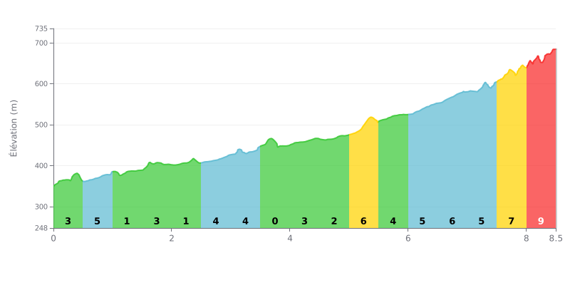
Difficulty breakdown: This HC climb covers 8.5 km with 497 m of elevation gain, at an average gradient of 5.8%. The start is easier, with a near-flat section at 1% over km 1.0-1.5, but the real difficulty kicks in between km 5.0-5.5 (7%) and km 6.0-7.0 (6%). The finale is the toughest: 7% over km 7.5-8.0, then 9% over km 8.0-8.5.
Tips for pacing your effort:
1. Save your legs from the start. Don't go out too hard over km 0.0-0.5 at 3%, because most of the real work happens in the second half of the climb.
2. Recover on the flat bits. Use the 1% section at km 1.0-1.5 to spin your legs out, eat and drink, and settle back into your rhythm before the steeper sections.
3. Hold a steady cadence in the final. At 9% over km 8.0-8.5, shift into an easier gear, stay seated, and keep a smooth, consistent cadence all the way to the summit.
8.5 km • 497 m D+
VAM: average climbing speed, based on elevation gain


Join thousands of cycling fans! Plan your rides, record your performance, track your progress and discover the finest climbs.
Live climb profile to pace your effort all the way to the top.

