
Paso de Jama is a climb of 5.0 kilometers (category 3). Paso de Jama tops out at 4,275 m above sea level. It is located in Jama, Jujuy, Argentina. The average gradient is 3.7% with a maximum of 13.1%. The climb has 183 meters of elevation gain.
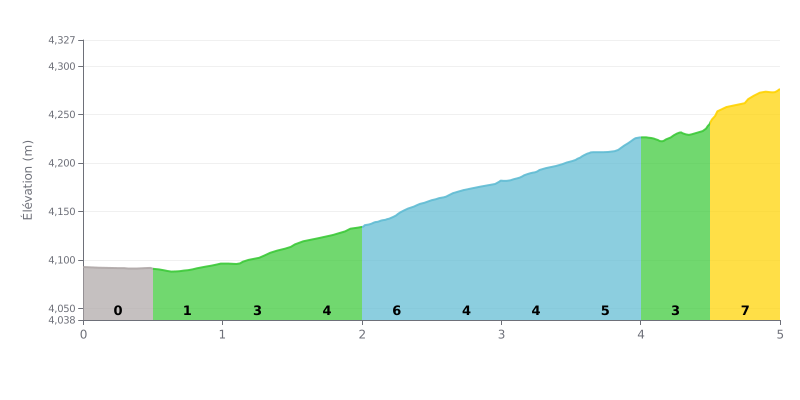
Difficulty breakdown: This category 3 climb (5 km at 3.7%) is moderate overall. The difficulty lies in its irregularity: an almost flat start followed by gradients that keep ramping up, with a tough finish at 7% over the last 500 metres.
Pacing tips:
1. Easy start: Use the first kilometre (0 to 1%) to settle into a rhythm without pushing too hard.
2. Steady in the middle: Hold a consistent pace over the central 3 km (gradients of 4 to 6%), which make up the heart of the climb.
3. Save something for the finish: Keep some energy in the tank for the final half kilometre at 7%, the steepest section of the route.
For cyclists who have climbed the Paso de Jama, the experience is first and foremost a sensory overload. They describe breathtaking landscapes, somewhere between high-altitude desert, dazzling salars and majestic volcanoes such as the Licancabur. The road, fully paved, snakes along at over 4,000 metres above sea level, offering spectacular views around every bend. Crossing the Andes here is a total immersion in wild, unspoiled nature, where you'll pass herds of llamas, guanacos and vicuñas.
But this beauty comes at a cost: the physical difficulty is a recurring theme in riders' accounts. The extreme altitude, often above 4,800 metres, hits hard with altitude sickness ("puna"): breathlessness, severe headaches, nausea and dizziness are common. Riders recommend acclimatising properly, chewing coca leaves, drinking plenty of fluids and packing very warm layers to cope with the biting cold and strong winds that can make every pedal stroke a grind.
The infrastructure up there is minimal. Riders stress the lack of services, no phone signal over long stretches, and the need to carry enough water and food. The border post itself is described as basic, with possible delays due to technical breakdowns or staff who are sometimes perceived as unfriendly, especially on the Chilean side. The crossing can take a long time, particularly if you have to wait behind the trucks.
Despite these challenges, riders agree on one thing: the adventure is unforgettable. The sense of solitude in this extreme environment, the reward of stunning scenery and the feeling of accomplishment after conquering the altitude make for a unique and deeply lasting experience for anyone who dares to take it on.
5.0 km • 183 m D+
VAM: average climbing speed, based on elevation gain


Join thousands of cycling fans! Plan your rides, record your performance, track your progress and discover the finest climbs.
Live climb profile to pace your effort all the way to the top.

