
Kyžlířov is a climb of 11.0 kilometers (category 3). Kyžlířov tops out at 606 m above sea level. It is located in Jakubčovice nad Odrou, Moravskoslezsko, Česko. The average gradient is 2.9% with a maximum of 7.8%. The climb has 319 meters of elevation gain.
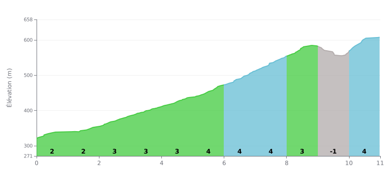
Difficulty breakdown: This 3rd category climb is moderately hard. The 2.9% average gradient over 11 km is manageable, but pacing is key: the first half (KM 0-5) is gentle (2-3%), then the gradient ramps up to 4% between KM 5 and 8, followed by a short downhill flat at KM 9 and a final 4% section to finish.
Tips for managing the effort:
1. Start easy: Use the first 5 km at low gradient (2-3%) to settle into a steady rhythm without burning your legs too early.
2. Prepare for the heart of the climb: Get ready to push harder from KM 5 onward. Don't blow up over the 4 km at 4%: find a gear that keeps your cadence smooth.
3. Use the false flat: The slight descent at KM 9 is a chance to recover briefly and save something for the final kilometre at 4%.
11.0 km • 319 m D+
VAM: average climbing speed, based on elevation gain


Join thousands of cycling fans! Plan your rides, record your performance, track your progress and discover the finest climbs.
Live climb profile to pace your effort all the way to the top.

