
Tizi n'Ait Hmed is a climb of 5.2 kilometers (category 1). The climb finishes at 2,992 m above sea level. It is located in Ighil N'Oumgoun, Drâa-Tafilalet ⴷⴰⵔⵄⴰ-ⵜⴰⴼⵉⵍⴰⵍⵜ درعة تافيلالت, Maroc ⵍⵎⵖⵔⵉⴱ المغرب. The average gradient is 7.5% with a maximum of 16.6%. The climb has 390 meters of elevation gain.
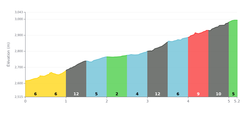
Difficulty breakdown: At 5.2 km, with 390 m of elevation gain and an average gradient of 7.5%, the Tizi n'Ait Hmed is a demanding climb, rated Cat 1. The profile is uneven: three sections are noticeably steeper, from km 3.0 to 3.5 (12%), from km 1.0 to 1.5 (11%) and from km 4.5 to 5.0 (11%), and they break your rhythm. The stretch from km 2.0 to 2.5, at only 2%, is the one real break, which makes the climb wear you down over time.
Pacing tips:
1. Start controlled. In the first few kilometres, from km 0.0 to 0.5 at 7%, don't go out too hard, because most of the effort comes in the second half of the climb.
2. Use the recovery section. Use the km 2.0 to 2.5 stretch at 2% to bring your cadence back up, drink and eat, since the 12% from km 3.0 to 3.5 comes right after.
3. Manage your accelerations. Tackle the 11% and 12% sections in an easy gear with a steady cadence, without surging, and save something for the final push from km 4.5 to 5.0.
Tizi n'Aït Hmed pass tops out at 3005 m. Several accounts call it the highest paved pass in Morocco, and it's crossed by car, motorbike or camper van as well as by bike. One cyclist says he climbed it from Tabant.
The road is the most debated part. It's bumpy in places, full of potholes, with a few stretches of gravel, and several people say it needs some maintenance. One rider even describes it as "almost non-existent". For the upper section, people say it's nearly all tarmac right to the top, with great switchbacks. Another mentions roadworks in progress. A cyclist who climbed from Tabant points out that going the other way, the track is loose sand and deep ruts, and it's a lot harder.
What comes up most often is the scenery. People talk about panoramic views, the M'Goun valley, the view over Ouzighimte, and a landscape one of them calls lunar. One rider compares the road to a longer version of the Boumalne-Dadès, with more than a hundred bends. Another describes it as one of the finest crossings from the High Atlas down to the Tafilalet oases. Depending on the date, snow changes the picture: one rider found snow under blue skies, another rode it without a trace of snow. One account says the pass is only open from about April to November, as snow closes it the rest of the year.
As for advice, riders stress caution: take your time, check the rest of the route carefully, ride attentively and avoid the stormy hours. One rider also mentions the mixed traffic, with motorbikes, cars and camper vans, without making it a major issue. The atmosphere, on the other hand, is described as friendly: you meet people from all sorts of countries, and everyone takes the time to chat at the top.
5.2 km • 390 m D+
VAM: average climbing speed, based on elevation gain


Join thousands of cycling fans! Plan your rides, record your performance, track your progress and discover the finest climbs.
Live climb profile to pace your effort all the way to the top.

