
Tizi n'Guifrès is a climb of 10.6 kilometers (hors catégorie). Tizi n'Guifrès tops out at 1,070 m above sea level. It is located in Iferhounene, Tizi Ouzou, Algérie ⵍⵣⵣⴰⵢⴻⵔ الجزائر. The average gradient is 6.4% with a maximum of 17.3%. The climb has 680 meters of elevation gain.
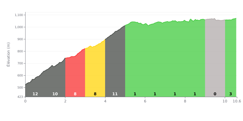
Difficulty breakdown: The Tizi n'Guifrès is a tough climb, covering 10.6 km at an average gradient of 6.4% with 680 m of elevation gain. The real work is concentrated in the first five kilometres, where the gradient hits 12% between km 0.0 and 1.0, then stays between 8% and 11% up to km 5.0. The second half is much more rolling, with 2% from km 5.0 to 6.0, then 1% from km 6.0 to 9.0 and 0% from km 9.0 to 10.0. The difficulty comes mostly from the length of the first third, which wears down your legs before the easier section.
Pacing tips:
1. Don't go out too hard On the km 0.0-1.0 stretch at 12%, keep a steady rhythm so you don't blow up before km 5.0.
2. Pick the right gear On the km 4.0-5.0 section at 11%, shift into an easier gear and keep a smooth cadence to spare your knees.
3. Make the most of the false flat Between km 5.0-6.0 at 2% and km 9.0-10.0 at 0%, recover, drink up, and get your cadence back to a steady spin before the final stretch from km 10.0-10.6 at 3%.
10.6 km • 680 m D+
VAM: average climbing speed, based on elevation gain


Join thousands of cycling fans! Plan your rides, record your performance, track your progress and discover the finest climbs.
Live climb profile to pace your effort all the way to the top.

