
Alto Boqueron is a climb of 5.4 kilometers (category 2). Alto Boqueron tops out at 1,393 m above sea level. It is located in Ibagué, Tolima, Colombia. The average gradient is 4.3% with a maximum of 12.6%. The climb has 233 meters of elevation gain.
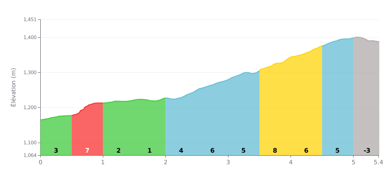
Difficulty breakdown: This 5.4 km climb with 233 m of elevation gain, averaging 4.3%, is rated Category 2. Its difficulty lies mainly in the uneven gradient: the toughest sections are KM 0.5-1.0 at 7% and especially KM 3.5-4.0 at 8%, while KM 1.0-1.5 (2%) and 1.5-2.0 (1%) give you some real breathers. The finale, with 6% over KM 4.0-4.5 then 5% over KM 4.5-5.0, means you need to save something in the tank.
Tips for the effort:
1. Pace your start Don't go out too hard over KM 0.0-0.5 at 3%, and settle into your rhythm before you hit the 7% ramp of KM 0.5-1.0.
2. Recover on the rolling section Use the 2% then 1% grades between KM 1.0-2.0 to drink, take on food, and loosen up your legs without losing too much time.
3. Save something for the end Tackle the 8% section of KM 3.5-4.0 seated and steady, so you still have enough left for the 6% of KM 4.0-4.5.
5.4 km • 233 m D+
VAM: average climbing speed, based on elevation gain


Join thousands of cycling fans! Plan your rides, record your performance, track your progress and discover the finest climbs.
Live climb profile to pace your effort all the way to the top.

