
Kunzum Pass is a climb of 141.7 kilometers (hors catégorie). Kunzum Pass tops out at 4,542 m above sea level. It is located in Hurling, Himachal Pradesh, India. The average gradient is 3.2% with a maximum of 13.8%. The climb has 4467 meters of elevation gain.
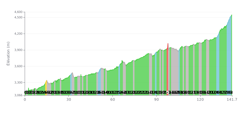
Difficulty analysis: With 4467m of climbing over 141.7km, this hors catégorie ascent is an extreme endurance test. The average gradient of 3.2% is deceptive: the profile is very uneven, alternating numerous flat stretches and descents (KM 15-18, 32-33, 55, 67-68, 86, 98-104) with critical steep sections, notably a kilometre at 10% (KM 97) and a demanding finish with three kilometres between 5% and 6% (KM 138-141).
Pacing advice:
1. Managing your pace: Hold a steady power output on the climbs. Use the flat or downhill sections (such as KM 98-104) to recover actively without pushing too hard, so you save your legs for the tough parts.
2. Prepare for the two key sections: The 10% ramp at KM 97 comes right after a descent. Hit it with fresh legs by easing off on the descent beforehand. Get mentally and physically ready for the steep finale (KM 138-141) by keeping some energy in reserve.
3. Hydration and fueling: The length of the climb (nearly 4h30 for a good climber) calls for a strict strategy. Fuel up regularly, especially during the first 100km, to avoid bonking in the decisive final hour.
For riders who have conquered the Kunzum Pass, the climb is described as the ultimate challenge, reserved for the most determined. Riders' accounts talk about a totally off-road route, strewn with rocks and dust, with steep ramps and plenty of hairpin bends. River crossings and a complete absence of mobile signal add to the adventure, requiring meticulous preparation and a suitable bike.
The payoff, though, is worth every ounce of effort. At the summit, at over 4500 metres above sea level, riders are greeted by a jaw-dropping view: a 360° panorama of snow-capped peaks, rugged valleys and a sea of prayer flags snapping in the wind. The air is thin and crisp, and the atmosphere is one of almost divine calm and serenity, enhanced by the little Kunzum Mata temple where travellers come to seek protection.
Riders feel a deep humility in the face of nature's power, with extremely strong winds and sudden weather changes, which can even bring snowfall in summer. Altitude demands respect, and it is advised not to linger at the top because of the risk of altitude sickness caused by oxygen deprivation.
This climb is definitely not for the faint-hearted, but for those seeking an authentic, raw adventure. According to riders' accounts, it is an experience that stays with you for life, offering a unique sense of communion with the immensity and raw beauty of the Himalayas.
141.7 km • 4467 m D+
VAM: average climbing speed, based on elevation gain


Join thousands of cycling fans! Plan your rides, record your performance, track your progress and discover the finest climbs.
Live climb profile to pace your effort all the way to the top.

