
Portezuelo Ocharaza is a climb of 74.6 kilometers (hors catégorie). Portezuelo Ocharaza tops out at 4,228 m above sea level. It is located in Huara, Región de Tarapacá, Chile. The average gradient is 4.2% with a maximum of 16.6%. The climb has 3147 meters of elevation gain.
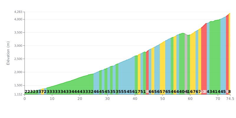
Climb analysis: Extremely long HC climb (74.6 km) with 3,147m of elevation gain. The 4.2% average gradient is deceptive. The real difficulty is the cumulative fatigue over a near-marathon distance, plus very steep sections (>8%) late in the climb (km 64-65 at 10%, km 73 at 9%), coming after more than 60 km of effort.
Pacing advice:
1. Pace management: Ride at a steady, controlled effort over the first 50 km (mostly 2% to 5% gradients) to save your legs. The real work starts after km 60.
2. Prepare for the spikes: Stay alert on the steep sections (km 41, 44, 64-65, 73-74.6). Drop into an easier gear before each one so you don't blow up your legs.
3. Fuelling strategy: At this length, you need to be strict with your hydration and nutrition. Plan a feed stop every 20-25 km to keep your energy levels steady.
74.5 km • 3147 m D+
VAM: average climbing speed, based on elevation gain


Join thousands of cycling fans! Plan your rides, record your performance, track your progress and discover the finest climbs.
Live climb profile to pace your effort all the way to the top.

