
Kawak Pass is a climb of 26.4 kilometers (hors catégorie). The climb finishes at 5,122 m above sea level. It is located in Hotan, 新疆维吾尔自治区 شىنجاڭ ئۇيغۇر ئاپتونوم رايونی, 中国. The average gradient is 5.0% with a maximum of 13.3%. The climb has 1312 meters of elevation gain.
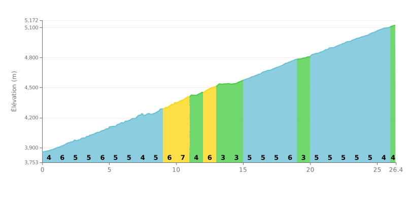
Difficulty breakdown: At 26.4 km for 1312 m of climbing and an average gradient of 5%, the Kawak Pass is a long, grinding climb, rated HC. There's no real respite: most of the kilometres sit between 4% and 6%, and the steepest stretch is between KM 10.0 and KM 11.0 at 7%. Only KM 13.0-14.0, at 2%, gives you a proper recovery before the grind resumes all the way to the top.
Tips for the effort:
1. Pace yourself from the bottom. On the opening kilometres (KM 0.0-1.0 at 4%), keep the cadence smooth and don't go over the top, because there's still over 25 km of sustained effort ahead.
2. Make the most of KM 13.0-14.0. This 2% section is your only chance to recover: eat, drink, and drop your shoulders before the second half of the climb.
3. Prepare for the 7% section. Tackle KM 10.0-11.0 seated, in a gear you can turn over comfortably, and don't blow up on the 6% slopes that follow.
26.4 km • 1312 m D+
VAM: average climbing speed, based on elevation gain


Join thousands of cycling fans! Plan your rides, record your performance, track your progress and discover the finest climbs.
Live climb profile to pace your effort all the way to the top.

