
Bumbálka is a climb of 7.5 kilometers (category 3). The climb finishes at 863 m above sea level. It is located in Horní Bečva, Zlínský kraj, Česko. The average gradient is 3.9% with a maximum of 7.4%. The climb has 291 meters of elevation gain.
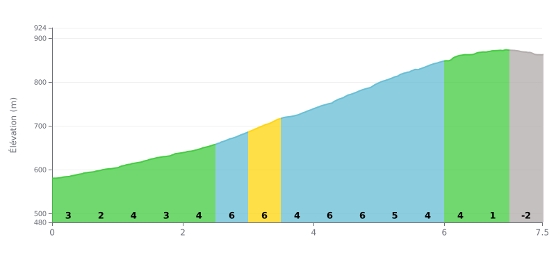
Difficulty breakdown: This 7.5 km climb with 291 m of elevation gain averages 3.9%, which makes it doable for most regular riders. The hard part is between km 2.5 and km 5.5, where the gradient sits at a steady 5 to 6% over 3 km. The first two km at 2% give you a chance to find your rhythm, and the finish, with 1% followed by a slight descent between km 7.0 and km 7.5, offers some welcome recovery.
Pacing tips:
1. Save something for the middle section On the opening 2% kilometres, keep it controlled so you still have something left when you reach km 2.5.
2. Hold your rhythm on the 6% stretches Between km 2.5 and km 5.0, where the gradient hits 6% several times, pick a gear you can keep turning in the saddle with a steady cadence.
3. Wind it up on the final flat Between km 6.5 and km 7.0, the gradient drops to 1%: that's the perfect moment to put the hammer down and finish strong before the descent.
The pass marks the border between the Czech Republic and Slovakia, and many riders stop there when crossing from one country to the other. The big car park serves as a rest stop, and one rider even spent the night there in a camper van.
On a clear day you can see far, all the way to the Lysá hora (“the bald mountain”). On a cloudy day, the peaks around stayed hidden. The car park is also a starting point for waymarked hikes, and the Beskydy ridge can be walked all the way to Kmínek or towards Javorníky. There's a memorial to a group of WWII partisans just nearby.
The buildings are the saddest part. Several people say the place used to be lively. The restaurant and guesthouse are closed, the chalet is empty, and there are no toilets nearby anymore. One rider thinks a small kiosk could at least operate in summer. There's a shop on the Beskydy road where people happily buy local products, such as frgály (traditional little cakes). Run-down sheds stand in the car park. One rider had fuel stolen overnight.
Traffic is the most frequently mentioned downside. The pass is a very busy road for cars, and the noise is always there. A Polish rider notes that the lorries go by without trouble and that you can ride there without worrying. As for the road itself, reports describe a paved surface leading to the Masaryk chalet, about 1.5 km away. On the gradients, they say almost nothing.
7.5 km • 291 m D+
VAM: average climbing speed, based on elevation gain


Join thousands of cycling fans! Plan your rides, record your performance, track your progress and discover the finest climbs.
Live climb profile to pace your effort all the way to the top.


Other climbs to Bumbálka
Within 20 km