
Trubianske sedlo is a climb of 7.5 kilometers (category 3). The climb finishes at 572 m above sea level. It is located in Horná Ves, n/a, Slovensko. The average gradient is 3.3% with a maximum of 5.9%. The climb has 249 meters of elevation gain.
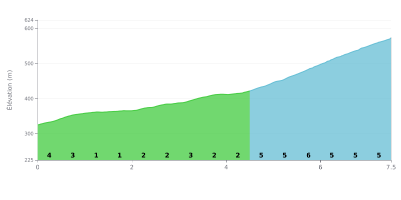
Difficulty breakdown: The Trubianske sedlo climb from Rudica is a Category 3 ascent covering 7.5 km for 249 m of elevation gain, for an average gradient of 3.3%. The start is punchy, with 4% between km 0.0 and 0.5, then 3% between km 0.5 and 1.0, before a more rolling section at 1% between km 1.0 and 2.0. The real test comes between km 4.5 and 7.5, where the gradient hovers between 5% and 6% with no real respite, gaining about 151 m of elevation.
Tips for managing your effort:
1. Pace yourself from the bottom: don't go out too hard on that first kilometer at 4%, and use the 1% stretch between km 1.0 and 2.0 to recover and settle into a steady rhythm.
2. Handle the 5-6% section: from km 4.5 onwards, stay seated, keep a smooth cadence, and avoid sudden surges that will cost you energy.
3. Save something for the finish: drink and eat before km 4.5 so you still have legs left for the last three kilometers to the summit.
7.5 km • 249 m D+
VAM: average climbing speed, based on elevation gain


Join thousands of cycling fans! Plan your rides, record your performance, track your progress and discover the finest climbs.
Live climb profile to pace your effort all the way to the top.

