
Ostry Dział is a climb of 4.6 kilometers (category 4). The climb finishes at 419 m above sea level. It is located in Harta, województwo podkarpackie, Polska. The average gradient is 3.6% with a maximum of 7.5%. The climb has 165 meters of elevation gain.
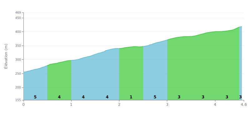
Difficulty breakdown: The Ostry Dział is a 4.6 km climb with 165 m of elevation gain, averaging 3.6%, which makes it a category 4 climb that's accessible but demanding on consistency. The difficulty comes from the alternation of 5% sections (KM 0.0-0.5, KM 1.0-1.5 and KM 2.5-3.0) and easier-rolling stretches, notably between KM 2.0 and KM 2.5 at 1%. The finale, between KM 3.5 and KM 4.5, stays honest with gradients of 4% then 3%. It's not a climb that wears you down through length, but don't underestimate it.
Tips for pacing yourself:
1. Don't go out too hard. The first 500 metres at 5% are tempting, but settle into a steady rhythm so you have something left for the middle section.
2. Recover on the flat. Between KM 2.0 and KM 2.5, the gradient drops to 1%: take advantage of it to sit back in the saddle, catch your breath and drink.
3. Save some legs for the finish. After KM 3.0, gradually build the pace again and use a gear that's easy enough to hold your cadence all the way to KM 4.5 at 3%.
From the summit of Ostry Dział (421 m), you can see part of the Połonina Wetlińska, with the Roh and the Hnatowe Berdo, plus other peaks in the Bieszczady and the Beskides Basses. That's what comes up most often in riders' reports.
Those who've done it recommend the climb mainly for the view. One rider simply writes that the scenery is stunning and that he'd tell anyone to come.
The one downside mentioned is parking: there isn't any. So sort out where to leave your bike or car before you start.
4.6 km • 165 m D+
VAM: average climbing speed, based on elevation gain


Join thousands of cycling fans! Plan your rides, record your performance, track your progress and discover the finest climbs.
Live climb profile to pace your effort all the way to the top.

