
Latuola Shankou is a climb of 13.0 kilometers (hors catégorie). The climb finishes at 4,040 m above sea level. It is located in Gyirong, 西藏自治区 བོད་རང་སྐྱོང་ལྗོངས།, 中国. The average gradient is 8.7% with a maximum of 15.6%. The climb has 1132 meters of elevation gain.
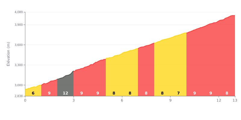
Difficulty breakdown: At 13 km with 1132 m of elevation gain and an average gradient of 8.7%, this climb is rightly rated HC (hors catégorie), and it demands a long, sustained effort. The first kilometre is gentler at 6%, but the difficulty sets in quickly with a spike to 12% between km 2.0 and km 3.0. After that, the gradient stays between 7% and 9% all the way to the summit, with no real respite, so it grinds your legs down little by little.
Tips for managing the effort:
1. Pace the start Over the first kilometre at 6%, keep the effort controlled so you save something for the rest of the climb.
2. Get ready for the 12% ramp Between km 2.0 and km 3.0, shift into an easier gear, stay seated, and keep a smooth, steady cadence.
3. Keep the effort even From km 4.0 to the finish, ride by your power rather than your speed, and eat and drink regularly.
13.0 km • 1132 m D+
VAM: average climbing speed, based on elevation gain


Join thousands of cycling fans! Plan your rides, record your performance, track your progress and discover the finest climbs.
Live climb profile to pace your effort all the way to the top.

