
Pico da Ibituruna is a climb of 9.7 kilometers (hors catégorie). The climb finishes at 1,100 m above sea level. It is located in Governador Valadares, Minas Gerais, Brasil. The average gradient is 11.2% with a maximum of 21.3%. The climb has 1081 meters of elevation gain.
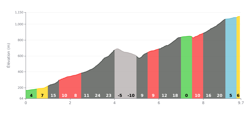
Difficulty breakdown: At 9.7 km with 1081 m of elevation gain and an average gradient of 11.2%, the Pico da Ibituruna is an HC climb. The first kilometres demand a stiff pace, with gradients of 8 to 15%, before the toughest section between km 3.0 and km 4.0, where the gradient hits 24% then 23%. The rest is uneven, with a short descent, a flat section at km 7.0-7.5, then a very steep finish between km 8.0 and km 9.0 (16 to 20%).
Tips for managing your effort:
1. Pace yourself from the start. Don't get carried away on the moderate early gradients (4 to 15%) so you still have something left for the 24% ramp between km 3.0 and km 4.0.
2. Recover on the descent from km 4.0 to km 5.0. Spin the legs easily, drink, and catch your breath without totally switching off your concentration.
3. Prepare for the wall between km 8.5 and km 9.0 (20%). Shift into an easy gear before the ramp, stay seated if needed, and keep a steady cadence.
Those who've been up the Pico da Ibituruna in Governador Valadares mostly rave about the view. From the top at 1,123 m you can see the whole city and the Rio Doce, with paragliders launching off the ramp. Lots of people reckon sunset is the best time to go, and one person went up for sunrise at 5:30 a.m. It's often chilly up there, especially in the morning, and several recommend bringing a jacket.
The road is the real crux. Part of it is tarmacked, but a good chunk is still cobbles or stone, with steep sections. Witnesses talk about cars pulled over with smoking engines, brakes cooking, a Kombi that broke down 200 m from the summit, and a little 1.0 engine struggling. The advice comes up again and again: climb in first or second, descend in first gear, low range, and use engine braking.
For cyclists, the accounts say very little about riding up. One person mentions a cycling event where the climb went "normally", with a strong but steady gradient. Others talk about mountain biking, downhill and trail riding on the singletracks. Most accounts are about cars, motorbikes, buses or walking. On foot, people take between 3 and 7 hours, and one person took twice the time Google predicted.
The downsides are plenty. Traffic is heavy, especially at weekends, with cars and motorbikes going up and down at the same time. Horses have been spotted on the road around the bends. The lanchonete is unreliable: some found it closed on weekdays, others say it only opens at weekends. The toilets are sometimes dirty or without water, there is rubbish at times, there's no medical support at the top and almost no shade. The sun hits hard, so you need plenty of water.
What stays with people is the quiet on weekdays, the grass for a picnic, and a view everyone thinks is beautiful. Several say they want to come back. Many, however, are asking for more facilities and better signage on the access road.
9.7 km • 1081 m D+
VAM: average climbing speed, based on elevation gain


Join thousands of cycling fans! Plan your rides, record your performance, track your progress and discover the finest climbs.
Live climb profile to pace your effort all the way to the top.

