
Slingerberg is a climb of 1.3 kilometers (category 4). The climb finishes at 107 m above sea level. It is located in Geulle aan de Maas, Limburg, Nederland. The average gradient is 5.0% with a maximum of 8.1%. The climb has 66 meters of elevation gain.
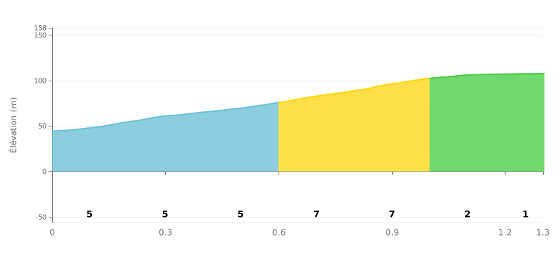
Difficulty analysis: The Slingerberg is a short climb: 1.3 km at an average gradient of 5% for 66 m of elevation gain, which puts it in Category 4. The hardest part is between KM 0.4-0.6 (6%) and KM 0.8-1.0 (7%), which make up the steepest section of the col. The finish, between KM 1.0-1.2 (2%) and KM 1.2-1.3 (1%), is almost flat and gives you a chance to pick up the pace.
Tips for pacing yourself:
1. Pace the start. In the KM 0.0-0.2 section at 5%, don't go out too hard so you have something left for later.
2. Prepare for the steep sections. In KM 0.6-0.8 and KM 0.8-1.0 (7%), pick a gear you can handle and keep a steady cadence rather than surging.
3. Go for it on the final stretch. Once you reach KM 1.0-1.2, where the gradient drops to 2%, pick up the pace and power to the top.
1.3 km • 66 m D+
VAM: average climbing speed, based on elevation gain


Join thousands of cycling fans! Plan your rides, record your performance, track your progress and discover the finest climbs.
Live climb profile to pace your effort all the way to the top.

