
Puerto de Erjos is a climb of 16.9 kilometers (hors catégorie). The climb finishes at 1,108 m above sea level. It is located in Garachico, Canarias, España. The average gradient is 6.5% with a maximum of 20.4%. The climb has 1097 meters of elevation gain.
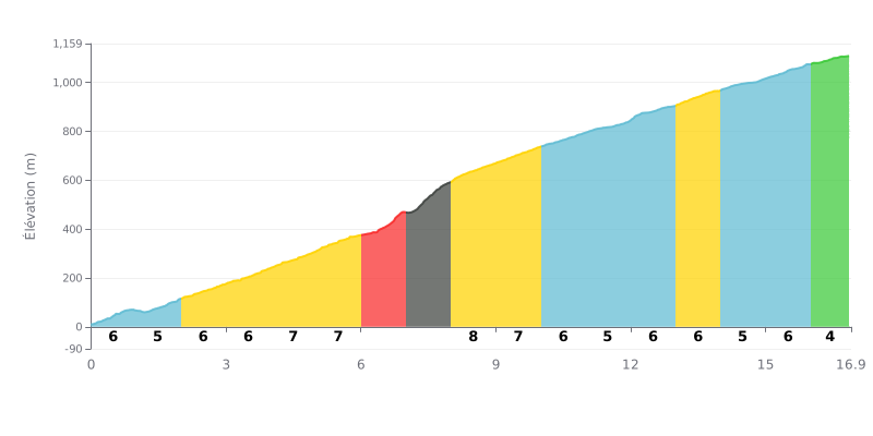
Difficulty breakdown: The Puerto de Erjos covers 16.9 km for 1097 m of elevation gain, with an average gradient of 6.5%, which makes it an HC climb mainly because of its sheer length. The hard part comes between km 6.0 and km 8.0, where the gradient ramps up to 9% and then hits 13% between km 7.0 and km 8.0. The rest of the climb stays fairly steady, between 5% and 7%, so you need to hold a constant effort and manage your energy carefully over the long haul.
Tips for pacing:
1. Pace yourself early. From km 0.0 to km 6.0, keep the effort strong but controlled. The 6% gradient at the bottom can easily burn through your reserves before the really hard section.
2. Prepare for the 13% section. Tackle km 7.0-8.0 in an easy enough gear, stay seated and keep a smooth, steady cadence to save your legs.
3. Recover on the upper slopes. Use the easier stretches at km 11.0-12.0 (5%) and km 16.0-16.9 (4%) to get some food and drink in and gradually build the pace back up.
Most of the feedback is about a lookout pass. Many people stop here for the view over the Teide, and several say they could see the Santiago del Teide valley and the sea at the same time, with Los Gigantes across the way. Some find the scenery superb, others just find it pretty, but the point comes up again and again.
The road is described as narrow and full of bends. One account mentions 40 to 45 minutes of switchbacks to climb from the north of the island, and another finds it steep and narrow, while still feeling the arrival is worth the effort. The reports don't give gradient figures or the exact width of the road surface, so it's best to go by these general impressions.
What comes up most is the contrast between the north and south of the island. People notice the difference in vegetation between the windward and the sheltered slopes, with laurisilva, pine and heather in places, and vineyards in the valley. The pass is also the starting point for several trails, towards Teno Natural Park, Masca or Monte del Agua. Most of the reports come from hikers and drivers rather than cyclists, so keep in mind that the experience described is mostly that of walking and driving.
The downsides come up too. The car park is small: reports mention room for 3 or 4 cars in one spot, 5 elsewhere, and 8 to 10 at another. At peak times spaces are scarce because of tourists. One report notes there's no place to rest at the viewpoint. Another warns that several rental cars have been broken into and emptied, five according to the account, so keep an eye on your belongings. In summer it's hot and dry, as one report from July points out. One of the starting trails was under works at the time of the visit.
16.9 km • 1097 m D+
VAM: average climbing speed, based on elevation gain


Join thousands of cycling fans! Plan your rides, record your performance, track your progress and discover the finest climbs.
Live climb profile to pace your effort all the way to the top.


Other climbs to Puerto de Erjos