
Lemkatel is a climb of 9.6 kilometers (category 1). Lemkatel tops out at 799 m above sea level. It is located in El Oueldja, سكيكدة ⵙⴽⵉⴽⴷⴰ, Algérie ⵍⵣⵣⴰⵢⴻⵔ الجزائر. The average gradient is 5.1% with a maximum of 12.4%. The climb has 495 meters of elevation gain.
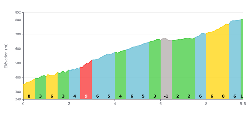
Difficulty breakdown: Lemkatel from Ouldja is a tough Category 1 climb: 9.6 km for 495 m of elevation gain, with an average gradient of 5.1%. The profile is uneven. The steepest sections are at km 2.5-3.0 (9%), km 0.0-0.5 (8%) and km 8.5-9.0 (8%). Between these sections, the easier stretches, like km 6.0-6.5 (-1%) or km 6.5-7.0 (2%), give you real recovery time. The real difficulty lies in these changes of rhythm, which make it hard to find a steady pace over the full climb.
Tips for managing your effort:
1. Pace your start. The first 500 metres at 8% tempt you to go too hard, but you need to save something for the sections that follow.
2. Recover on the easier sections. Between km 6.0 and 7.0, roll down the dip and then the false flat at 2% to rest your legs and get your breath back.
3. Finish strong. After the 8% section at km 8.5-9.0, stay in a gear you can handle, and get out of the saddle now and then through km 9.0-9.5 at 5% to finish strong.
9.6 km • 495 m D+
VAM: average climbing speed, based on elevation gain


Join thousands of cycling fans! Plan your rides, record your performance, track your progress and discover the finest climbs.
Live climb profile to pace your effort all the way to the top.


Within 20 km