
Makljen is a climb of 11.6 kilometers (hors catégorie). The climb finishes at 1,115 m above sea level. It is located in Duge, Federacija Bosne i Hercegovine, Bosna i Hercegovina / Босна и Херцеговина. The average gradient is 5.7% with a maximum of 12.9%. The climb has 656 meters of elevation gain.
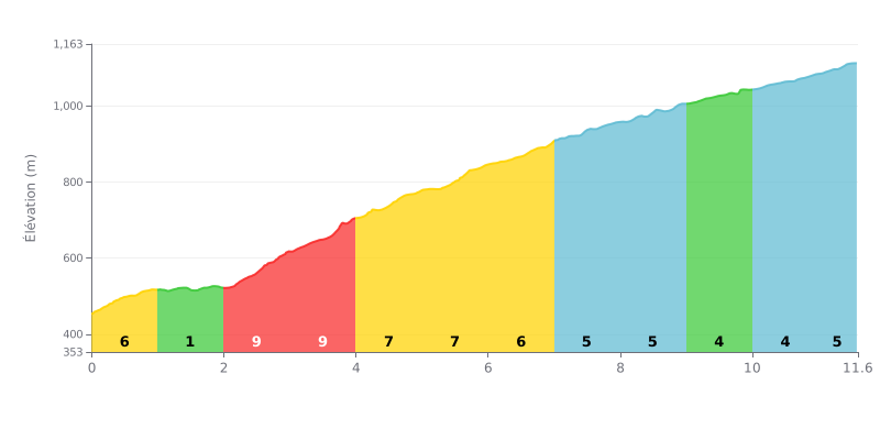
Difficulty breakdown: The Makljen from Duge is an 11.6 km climb with 656 m of elevation gain, averaging 5.7%, which earns it its HC rating. The real test comes in the first half, especially from km 2.0 to km 4.0, where the gradient hits 10% and then 9%. After that, the road stays tough at 7% until km 6.0, then eases gradually with 4% between km 9.0 and km 11.0, before ramping back up to 5% on the final section.
Tips for managing your effort:
1. Start steady. Don't get carried away in the first kilometre at 6%, because the 9 and 10% sections that follow will drain your reserves fast.
2. Make the most of the breather. The stretch from km 1.0 to km 2.0, at just 1%, is the perfect spot to drink, eat and recover before the steepest part.
3. Keep a steady rhythm late on. Between km 9.0 and km 11.0, at 4%, hold a constant cadence so you have enough left in the tank for the final 5% section.
Those who have ridden up Makljen talk about the views first. Several recommend stopping for at least five minutes to take in the mountains and valleys of Bosnia and Herzegovina. Others mostly say they stopped for photos, and that the scenery just stops you dead in your tracks.
Many find the climb beautiful and enjoyable for a ride. The words that come up again and again are simple: superb, fantastic, divine. One cyclist says it's his mountain. The reports don't say much about the gradient or how hard the climb is.
There are negatives too. One cyclist rates the access road to the mountain as in very poor condition and the cleanliness as lacking. Another says the monument at the site is destroyed and vandalised.
The place has a history, and one rider who visited the village finds it beautiful. But he also writes that, more than twenty years after the war, Muslims and Catholics still can't live together, and that hatred remains very deep among everyone.
11.6 km • 656 m D+
VAM: average climbing speed, based on elevation gain


Join thousands of cycling fans! Plan your rides, record your performance, track your progress and discover the finest climbs.
Live climb profile to pace your effort all the way to the top.


Other climbs to Makljen