
Batad Saddle is a climb of 12.8 kilometers (hors catégorie). The climb finishes at 1,306 m above sea level. It is located in Ducligan, Ifugao, Philippines. The average gradient is 10.6% with a maximum of 19.9%. The climb has 1351 meters of elevation gain.
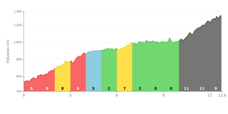
Difficulty breakdown: This HC climb covers 12.8 km at an average gradient of 10.6%, which makes it a long and punishing test. The first four kilometres, between 8% and 9%, demand a sustained effort right from the gun, followed by a more rolling section between km 4.0 and km 10.0, where the gradient drops to 0% in places. The real damage is done in the closing stretch, from km 10.0 to km 12.8, with gradients of 10% to 11% that will really test your legs.
Tips for managing the effort:
1. Pace yourself from the start On the km 0.0-1.0 section at 8%, keep a steady rhythm so you still have something in the tank for later.
2. Recover between km 8.0 and km 10.0 These almost flat stretches are your chance to drink, eat and get your breathing back under control before the final push.
3. Tackle the final with the right gear On the 11% ramps from km 10.0 to km 11.0, opt for an easy gear and a steady cadence, and stay seated to keep the effort under control.
What comes up most in the reports is the view. The upper and lower viewpoints are both accessible, there's a car park and a small shop run by a very welcoming lady, where you can sip a coconut while taking in the scenery. Several riders describe a 360-degree view. Some went up for sunrise. Entry is free, but the toilets cost a small fee.
To reach the village of Batad, the road is now sealed further down, so you can drive a bit further than before. You still have to walk the rest of the way. According to riders' experiences, it takes between 20 and 45 minutes to reach the tourist area with the guesthouses and restaurants, and one rider says an hour depending on age and fitness. In January, during the dry season, the walk was judged not too hard. The advice that comes up most: take it easy and watch where you put your feet.
A few riders found the tricycle descent absolutely sensational. The place is quiet, away from traffic and pollution, surrounded by huge mountains. It's cool, and you can take it easy there. Phone signal is scarce, with only one spot in Batad that gets a decent connection. Several people describe it as a place where cyclists feel very welcome.
There are also some caveats. One account warns that the roads, the walks, the guides, the food and the transport seemed dangerous to them, and mentions tourists who died at poorly supervised sites. Another reminds us that the climb demands a good level of fitness. Overall, the takeaway is to stay careful on site.
12.8 km • 1351 m D+
VAM: average climbing speed, based on elevation gain


Join thousands of cycling fans! Plan your rides, record your performance, track your progress and discover the finest climbs.
Live climb profile to pace your effort all the way to the top.

