
Golden Gate Highlands is a climb of 5.1 kilometers (category 1). Golden Gate Highlands tops out at 2,147 m above sea level. It is located in Dihlabeng Local Municipality, Free State, South Africa. The average gradient is 5.4% with a maximum of 13%. The climb has 279 meters of elevation gain.
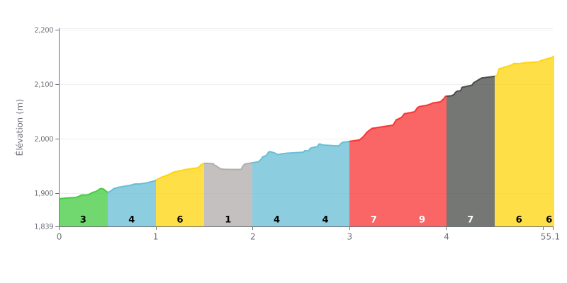
Climb difficulty analysis: This 1st category climb has a deceptive profile. The real difficulty is concentrated in the second half, with a demanding sequence of 10%, 8% and 8% gradients between km 3.0 and km 4.5. The first kilometer and a half is relatively gentle, while an almost flat section at km 1.5-2.0 (1%) offers a brief breather before the main effort.
Tips for managing the effort:
1. Pacing: Resist the urge to go out too hard on the early moderate gradients. Save your legs for the 10% wall starting at km 3.0.
2. Make the most of the breather: Use the 1% section (km 1.5-2.0) to recover actively (spin the legs easy) and get ready for the steep ramps ahead.
3. Mental approach: Tackle the climb in three parts: a moderate start, a strategic breather, then a hard final section to manage by breaking the effort into chunks all the way to the summit.
Cyclists who have ridden the roads of Golden Gate Highlands National Park describe an breathtaking experience, where the landscape is the real star of the show. The huge sandstone formations, glowing gold and ochre in the setting sun, make for a jaw-dropping backdrop. Riders often mention the sense of calm and vastness, as if time slows down in the middle of these majestic mountains.
The riding itself is marked by a well-maintained road according to most riders' reports, which lets you fully enjoy the scenery. However, cyclists have to share the tarmac: the main road (R712) is described as a fairly busy through route. So stay alert, especially since some car drivers tend to take the corners fast. The numerous viewpoints along the route make it easy to stop safely, whether to snap a photo or just take in the view of the Maluti mountains and the Drakensberg.
For those who want to get away from the main road, riders strongly recommend buying a permit to tackle the two scenic loops (Oribi and Blesbok). These secondary roads, also well surfaced, climb higher into the mountains and offer even more spectacular views, with far less traffic. It's a chance for a quieter climb, with the bonus of spotting zebras, wildebeest, or herds of antelope.
The climbing can be physically demanding, especially if you choose routes with significant elevation gain, and riders report that the wind can be a serious challenge at altitude. But the effort always pays off with unforgettable panoramic views. Some reviews also stress the need to respect this unique natural setting, noting that the park is sometimes affected by bad behaviour such as littering or noise, and urging everyone to ride responsibly and in an eco-friendly way.
5.1 km • 279 m D+
VAM: average climbing speed, based on elevation gain


Join thousands of cycling fans! Plan your rides, record your performance, track your progress and discover the finest climbs.
Live climb profile to pace your effort all the way to the top.

