
Sympetro is a climb of 7.0 kilometers (category 1). The climb finishes at 413 m above sea level. It is located in Cos, Περιφέρεια Νοτίου Αιγαίου, Ελλάς. The average gradient is 5.4% with a maximum of 10.8%. The climb has 379 meters of elevation gain.
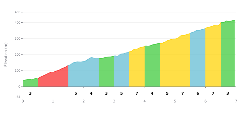
Difficulty analysis: With 7 km at an average gradient of 5.4% and 379 m of elevation gain, this Category 1 climb demands a sustained, steady effort. The crux comes between km 0.5 and km 1.5, where the gradient hits 8% and then 9%. The second half is punctuated by stretches at 7% (km 3.5-4.0, 5.0-5.5 and 6.0-6.5). The sections at 3% (km 0.0-0.5, 2.5-3.0, 4.0-4.5 and 6.5-7.0) offer welcome breathers, but they don't always ease the pressure enough.
Tips for managing the effort:
1. Pace the start The first 500 metres at 3% are deceptive: keep a moderate rhythm so you reach km 0.5 with fresh legs.
2. Getting through km 0.5 to km 1.5 Stay seated, pick a light gear and keep a smooth cadence of around 80 to 90 rpm over these two kilometres at 8-9%.
3. Recovering on the flat-ish sections Use the 3% stretches (km 2.5-3.0 and 4.0-4.5) to drink, eat and get your legs turning again, so you have something left for the 7% ramps and the final km 6.5-7.0.
7.0 km • 379 m D+
VAM: average climbing speed, based on elevation gain


Join thousands of cycling fans! Plan your rides, record your performance, track your progress and discover the finest climbs.
Live climb profile to pace your effort all the way to the top.

