
Paso del Condor is a climb of 21.3 kilometers (hors catégorie). Paso del Condor tops out at 2,076 m above sea level. It is located in Comisión Municipal de El Trapiche, San Luis, Argentina. The average gradient is 5.1% with a maximum of 15.1%. The climb has 1085 meters of elevation gain.
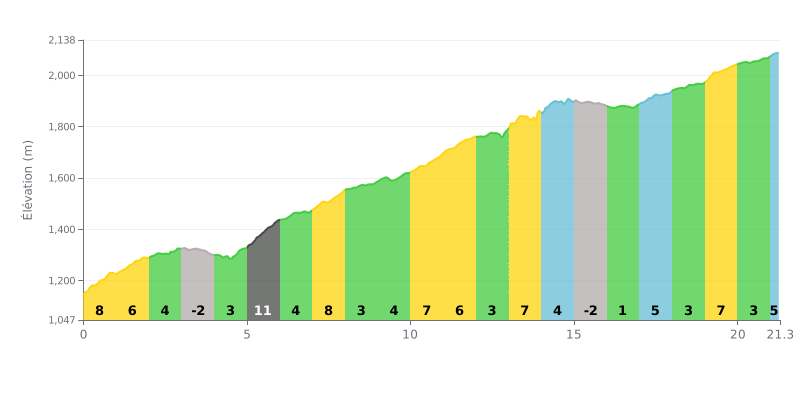
Difficulty breakdown: At 21.3 km with 1085 m of elevation gain for an average gradient of 5.1%, the Paso del Condor from Río Grande is a very demanding HC climb. The real challenge is the consistency of effort: the 8% ramps at km 0-1, km 7-8 and km 10-11, plus the 11% kicker at km 5-6, keep the pressure on. The easier sections, often between 3 and 6%, never give you a proper recovery. The last third, with 7% at km 19-20, comes after a long string of climbs.
Tips for managing your effort:
1. Go easy off the line. Don't get carried away on the 8% at km 0-1: ride at your own pace so you still have something in the tank before km 5-6.
2. Make the most of the descents. Recover on the downhill at km 3-4 (-3%) and km 15-16 (-2%), keeping your legs loose and spinning steadily.
3. Save something for the finish. Keep some strength for the 7% at km 19-20 and for the final stretch, from km 21.0 to 21.3, at 5%, where you need to stay controlled all the way to the summit.
According to riders who have climbed it, the ascent to Paso del Condor - Hotel de montaña is an adventure that starts with a committing approach. The last few kilometers are on a ripio track of roughly 4 to 5 km, with a few river crossings (vados) to negotiate. Most reports say that with some care the access is perfectly doable, even in ordinary road cars, but some warn that the track can be rough on the nerves and get much harder in bad weather or after rain, when the fords become impassable.
The effort is more than repaid by an exceptional natural setting. Riders describe a spot tucked into the heart of the mountains, with total peace and quiet, broken only by the wind in the pines and birdsong. For many, this immersion in the wild, far from the noise of the city, is the whole point of the ride.
The atmosphere at the top, at the hotel, is often described as welcoming and warm. Riders praise the food, with dishes often called excellent, sometimes made with produce from the kitchen garden. However, some report a few things to be aware of, mainly prices that feel steep for meals and services, and very patchy Wi-Fi and phone signal, which is hardly surprising given how isolated the place is.
In short, this climb is presented as an authentic experience for those looking for isolation and raw contact with nature. It takes some preparation, especially when it comes to the weather and the state of the track, but in return it gives you a sense of escape and calm that is hard to find anywhere else.
21.3 km • 1085 m D+
VAM: average climbing speed, based on elevation gain


Join thousands of cycling fans! Plan your rides, record your performance, track your progress and discover the finest climbs.
Live climb profile to pace your effort all the way to the top.


Other climbs to Paso del Condor