
Abra Picavilque is a climb of 42.2 kilometers (hors catégorie). Abra Picavilque tops out at 5,065 m above sea level. It is located in Colchane, Región de Tarapacá, Chile. The average gradient is 3.7% with a maximum of 18.9%. The climb has 1575 meters of elevation gain.
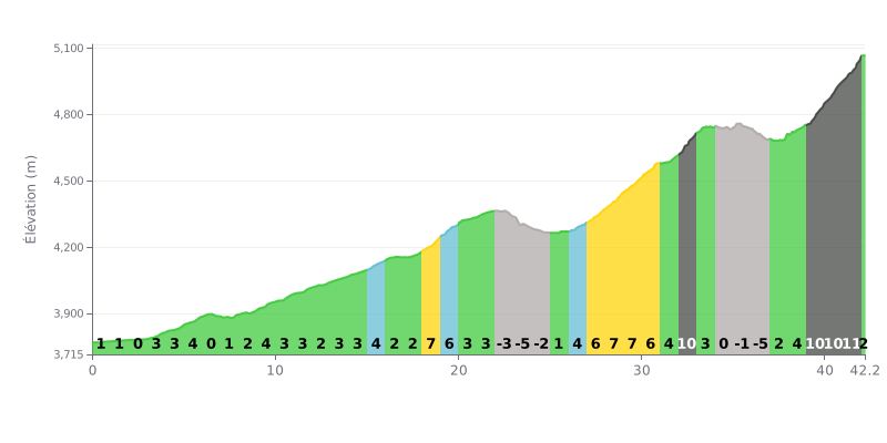
Difficulty breakdown: This 42.2 km climb gets genuinely hard in the final part. The first half (KM 0-21) is moderate, averaging 2.5%, with three kilometres of descent (KM 22-24) thrown in. The gradient ramps up progressively from KM 27, peaking over the last 3 kilometres with brutal 10% and 11% pitches.
Pacing advice:
1. Pace yourself: Ride the first 25 kilometres within yourself to save your legs. Your main effort should be kept for the hard section between KM 27 and 42.
2. Use the flat bits: The 0% sections (KM 6-7, KM 34) and the gentle descents (KM 22-24, KM 35-36) are key chances to recover and get some fluids in.
3. Save something for the finish: Keep some physical and mental reserves for the final, extremely steep section (KM 39-41 at 10-11%), which will make or break your overall time.
42.2 km • 1575 m D+
VAM: average climbing speed, based on elevation gain


Join thousands of cycling fans! Plan your rides, record your performance, track your progress and discover the finest climbs.
Live climb profile to pace your effort all the way to the top.

