
Langar Pass is a climb of 12.3 kilometers (hors catégorie). The climb finishes at 1,414 m above sea level. It is located in Chuya, Navoiy Viloyati, Oʻzbekiston. The average gradient is 5.8% with a maximum of 13.5%. The climb has 717 meters of elevation gain.
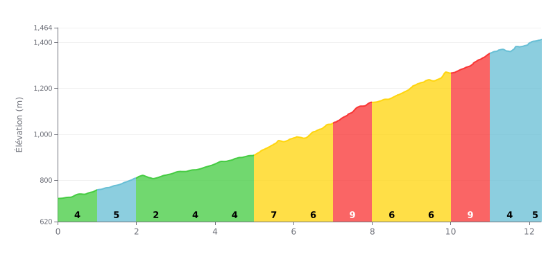
Difficulty breakdown: At 12.3 km for 717 m of elevation gain and an average gradient of 5.8%, the Langar Pass is a long, steady climb, and it's rightly rated Hors Catégorie. The first five kilometres, between 3% and 5%, let you settle in, but the difficulty ramps up clearly from km 5.0 to km 8.0, with gradients of 7% to 9%. The stretch from km 10.0 to km 11.0, at 9%, is the hardest section before a rolling finish at 5%.
Tips for managing your effort:
1. Don't go out too hard. On the km 0.0 to km 5.0 section, with moderate gradients between 3% and 5%, ride at a steady pace and save some in the tank for what's coming.
2. Prepare for the ramp-up from km 5.0 to km 8.0. Shift into an easier gear from km 5.0, where the gradient hits 7%, then hold a smooth cadence before the 9% section from km 7.0 to km 8.0.
3. Handle the km 10.0 to km 11.0 section. Stay seated, keep a smooth cadence on the 9% gradient, and use the easier 5% stretch from km 11.0 to km 12.3 to push back on the pedals if you still have some legs left.
12.3 km • 717 m D+
VAM: average climbing speed, based on elevation gain


Join thousands of cycling fans! Plan your rides, record your performance, track your progress and discover the finest climbs.
Live climb profile to pace your effort all the way to the top.

