
Navgarzon Dovon is a climb of 21.5 kilometers (hors catégorie). Navgarzon Dovon tops out at 2,220 m above sea level. It is located in Chinor, Toshkent Viloyati, Oʻzbekiston. The average gradient is 6.3% with a maximum of 14.8%. The climb has 1350 meters of elevation gain.
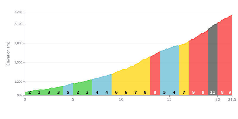
Difficulty breakdown: This climb gets progressively harder, and the gradient ramps up noticeably. The first 10 km (average gradient 3.5%) are a warm-up. Things get serious after KM 10, with a demanding stretch of 6% to 8% over 4 km. The final section, from KM 17 to the summit, is brutal, with gradients between 7% and 11%, peaking at 11% at KM 19. At 21.5 km and 1350m of elevation gain, it's a well-earned Hors Catégorie (HC) climb.
Pacing tips:
1. Pacing: Use the first 10 km, which are gentler, to settle into a steady rhythm and save your legs. Whatever you do, don't go out too hard.
2. Prepare for the key sections: Ease off a touch before the steep parts (KM 11-13 and KM 17-20) to keep a smooth cadence and avoid blowing up.
3. Mental prep for the final: Know that the last 5 km are the hardest (average gradient 8.6%). Save something in the tank for that final push.
21.5 km • 1350 m D+
VAM: average climbing speed, based on elevation gain


Join thousands of cycling fans! Plan your rides, record your performance, track your progress and discover the finest climbs.
Live climb profile to pace your effort all the way to the top.

