
Naagdhunga pass is a climb of 3.0 kilometers (category 1). The climb finishes at 1,506 m above sea level. It is located in Chhatre Dyaurali, बागमती प्रदेश, नेपाल. The average gradient is 10.3% with a maximum of 17.9%. The climb has 306 meters of elevation gain.
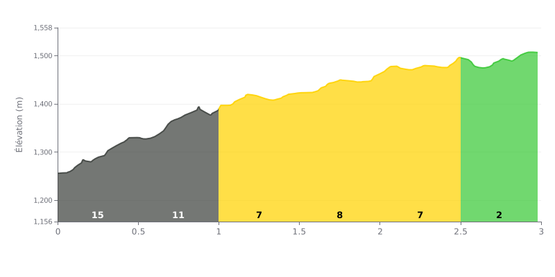
Difficulty breakdown: The Naagdhunga pass is a short but punchy Cat 1 climb, with 3 km for 306 m of elevation gain and an average gradient of 10.3%. The real test comes in the first kilometre, where the gradient hits 15% on KM 0.0-0.5 and then 13% on KM 0.5-1.0, which soon has your legs screaming. The rest is more manageable, with stretches at 6% and then 3% on KM 2.5-3.0, but you need to reach the steep section with something left in the tank.
Tips for pacing the climb:
1. Pace yourself from the bottom: don't go out too hard on the 15% section of KM 0.0-0.5. Settle into a steady rhythm and stay seated.
2. Make the most of the easier sections: use the 6% stretch on KM 1.0-1.5 to recover and build your speed back up before the 9% section on KM 1.5-2.0.
3. Push on the final stretch: on KM 2.5-3.0 at 3%, picking up the pace lets you finish strong and use whatever energy you have left.
Cyclists who have come through Naagdhunga mostly talk about the view over the Kathmandu Valley and what goes on at the checkpoint. Many see it as the gateway to the valley, the route you take coming in from western Nepal or from Pokhara. According to one rider, part of the valley can be seen from the pass.
Those who took the time to look describe a great mountain view, lush greenery, waterfalls and fresh air. One cyclist says the place is quiet and cool, and he stayed at a hotel up there.
The most frequent complaint is the traffic. Several people mention frequent jams, and one rider feels the checkpoint slows everyone down. The roads are described as poor and tough, and one person criticises the authorities for not improving this stretch.
According to a traditional explanation, the name comes from naag, meaning serpent in an old legend. One rider describes the spot as a religious site visited by Hindus.
The reports are short and say little about the climb itself. The length, the gradients and the exact condition of the surface are almost never described.
3.0 km • 306 m D+
VAM: average climbing speed, based on elevation gain


Join thousands of cycling fans! Plan your rides, record your performance, track your progress and discover the finest climbs.
Live climb profile to pace your effort all the way to the top.


Within 20 km