
Alto del Sifón is a climb of 1.8 kilometers (category 3). Alto del Sifón tops out at 4,149 m above sea level. It is located in Casabianca, Tolima, Colombia. The average gradient is 5.4% with a maximum of 17.6%. The climb has 98 meters of elevation gain.
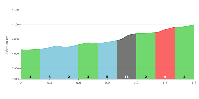
Difficulty analysis: At 1.8 km with an average gradient of 5.4%, the Alto del Sifón is a short but demanding climb, rated Category 3 for 98 m of elevation gain. The start, at 1% over KM 0.0-0.2, is almost flat, then the difficulty concentrates between KM 1.0-1.2, with a gradient of 12%. The KM 1.4-1.6 section at 9% carries on this effort and makes the second half of the climb especially selective. KM 1.6-1.8, at 4%, offers a slight breather before the finish.
Tips for managing the effort:
1. Pace yourself from the bottom Use the first 200 metres at 1% to find a steady rhythm and avoid going too hard before the steep sections.
2. Prepare for the KM 1.0-1.2 wall Shift onto a gear light enough, stay seated and keep a smooth cadence to save your legs over the 12% ramp.
3. Recover over KM 1.2-1.4 This 2% stretch is your chance to catch your breath and build back up before tackling the 9% section of KM 1.4-1.6, where you'll need to stay focused.
Those who have climbed the Alto del Sifón talk about the road first. It's been paved since 2023, and several say it's in excellent condition. The summit sits at 4193 metres. One cyclist who did the whole climb on the bike says he suffered from the cold the entire way up.
The climb starts in Murillo and joins the road coming from Fresno. The scenery is pure páramo, with frailejones, those big high-altitude plants, lining the way, and waterfalls tumbling down close to the road. Several riders reckon it's the most beautiful road in Colombia. Along the way you can buy coca tea, which some find really good.
Everyone agrees it's hard. Witnesses describe a demanding, punishing climb. According to one account, the col was added to the route at the last minute during the 2024 Vuelta a Colombia, and it would be the hardest climb ever used in a bike race. It would also be the highest pass ever crossed in a race, by a few metres above the Pico del Águila (Eagle Peak) in Venezuela.
The weather changes fast. Those who set off in the afternoon got fog, rain and a biting cold, and the views weren't good. The advice comes up again and again: start early in the morning to see the Nevado del Ruiz, and pack a fleece and a rain jacket. Cyclists also need to be careful, because the road is shared with cars, 4x4s and motorbikes. Heavy vehicles are banned, but it stays very busy on weekends, public holidays and during school holidays, when lots of visitors head up.
Several accounts also point to problems. Litter is lying around on the main road. Quad bikes ride through and make a lot of noise, disturbing the wildlife and the calm of the place. Some people have seen animals run over on the road. One visitor thinks tourist numbers could damage the site if nothing changes. Others ask people not to damage the frailejones, not to cross the fences, and not to drop any litter.
1.8 km • 98 m D+
VAM: average climbing speed, based on elevation gain


Join thousands of cycling fans! Plan your rides, record your performance, track your progress and discover the finest climbs.
Live climb profile to pace your effort all the way to the top.

