
Bukit Pucaktedung is a climb of 10.9 kilometers (category 1). The climb finishes at 767 m above sea level. It is located in Carangsari, Bali, Indonesia. The average gradient is 3.6% with a maximum of 15.9%. The climb has 394 meters of elevation gain.
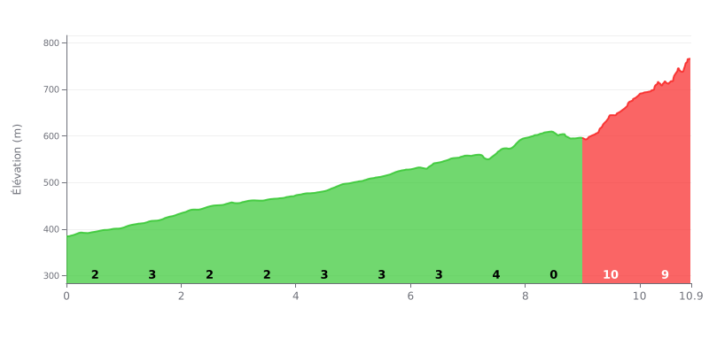
Difficulty analysis: This Category 1 climb is split into two parts. The first eight kilometers, with gradients between 2% and 4% depending on the section, form a steady climb that gradually grinds down your legs without any real break. The km 8.0-9.0 section, at 0%, offers a short breather before the finale, where km 9.0-10.0 at 10% and km 10.0-10.9 at 9% pack most of the difficulty into nearly 2 km. With 394 m of elevation gain over 10.9 km, the ascent demands good pacing from the start.
Climbing tips:
1. Don't start too fast. On the km 0.0-1.0 section at 2%, keep the effort moderate so you don't blow your reserves before the steepest parts.
2. Make the most of the false flat. On the km 8.0-9.0 section at 0%, recover, hydrate and sort out your gearing for the final push.
3. Manage the finale. Hit the km 9.0-10.0 section at 10% with a steady rhythm, then save some strength for the km 10.0-10.9 section at 9%, staying seated if you can.
Testimonials for this climb are very short, but one message sets the tone. Someone simply wrote "Awesome View", meaning the view from the top is worth the detour.
The second message is in Indonesian and is geotagged at the Pura Puncak Tedung temple in Sulangai, Petang district, Badung, Bali. Roughly, it says that even when you're not tired, you need to know how to rest, and even when you're not rich, you need to know how to be grateful.
Beyond that, these testimonials say nothing about the length of the climb, its gradient, the condition of the road, or the traffic. To find out what the climb is really like, you'll have to either ride it yourself or look for more detailed accounts.
10.9 km • 394 m D+
VAM: average climbing speed, based on elevation gain


Join thousands of cycling fans! Plan your rides, record your performance, track your progress and discover the finest climbs.
Live climb profile to pace your effort all the way to the top.

