
Pukemako is a climb of 4.3 kilometers (category 1). The climb finishes at 384 m above sea level. It is located in Cambridge, Waikato, New Zealand / Aotearoa. The average gradient is 7.1% with a maximum of 15.3%. The climb has 303 meters of elevation gain.
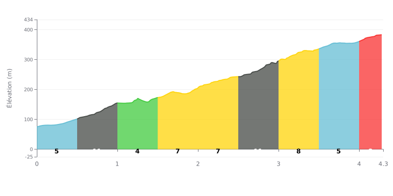
Difficulty breakdown: The Pukemako from Fencourt is a tough climb: 4.3 km for 303 m of elevation gain, with an average gradient of 7.1%. The profile is uneven. The km 0.5-1.0 and km 2.5-3.0 sections hit 11%, while km 1.0-1.5 gives you a breather at 4%. Rated Category 1, the climb is decided mostly by consistency and how you handle the steepest ramps.
Tips for pacing the effort:
1. Start easy. Don't go out too hard over km 0.0-0.5 at 6%, because the 11% ramp at km 0.5-1.0 comes quickly and can drain your legs.
2. Use the recovery section. Take advantage of the 4% stretch at km 1.0-1.5 to recover, pick up your cadence again and drink before the harder middle section.
3. Save something for the finish. After the 8% section at km 3.0-3.5 and the 5% section at km 3.5-4.0, the 8% ramp at km 4.0-4.3 still demands power, so don't burn all your matches before the summit.
The top is a lookout over Cambridge and the Waikato. Reviews mention nicely mown lawns, picnic tables, toilets and a big car park. Several people recommend coming late in the afternoon for the sunset, which you see across the way, towards Mount Pirongia. One person got lucky and arrived above the clouds, with the view opening up as the mist lifted.
The site, also known as Gudex, Maungakawa or Sanatorium Hill, has a visible history. There are ruins of a sanatorium. The 25-room mansion built in the 1890s later belonged to the Crown, which turned it into a sanatorium for tuberculosis patients, then a convalescent home for soldiers after the First World War.
On foot, the path up to the lookout is short, but the forest loop lets you ride or walk for longer. Under the trees it's cool, you can hear the birds, and the quiet is often mentioned. The track has a lot of steps. After rain the ground can get muddy, and one person said the mud made it hard to walk.
The access road, Maugakawa Road, is the most technical section. It has about five hairpins, some of them double hairpins, and corners that come one after another both up and down. Feedback on this road mostly comes from motorists: small cars handle it more comfortably, turbo cars don't make good use of their power, and heavy cars struggle on the descent, especially in a left-hander that catches people out. A loop lets you link up with the Te Miro school, with faster roads around it.
4.3 km • 303 m D+
VAM: average climbing speed, based on elevation gain


Join thousands of cycling fans! Plan your rides, record your performance, track your progress and discover the finest climbs.
Live climb profile to pace your effort all the way to the top.

