
Lachung La is a climb of 94.6 kilometers (hors catégorie). Lachung La tops out at 4,652 m above sea level. It is located in Bringbong, Sikkim, India. The average gradient is 7.1% with a maximum of 15.9%. The climb has 6734 meters of elevation gain.
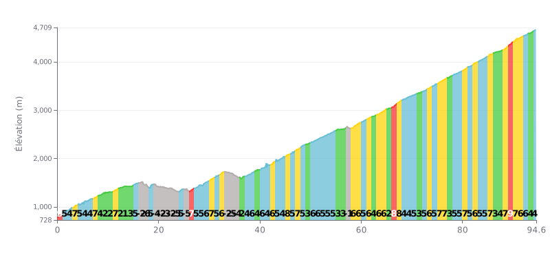
Difficulty analysis: With 6734m of elevation gain over 94.6 km (average gradient 7%), this climb is extremely demanding, comparable to a queen stage of the Tour de France. The difficulty lies in its length and the repeated sections at 7-9%, especially in the final 10 km (gradients of 7-9%). The descending sections (KM 16-25) offer temporary respite but break your rhythm.
Pacing advice:
1. Hold a steady rhythm by aiming for a constant power output on the climbs, especially on the steep sections (KM 45-48, 88-90).
2. Make the most of the descents (KM 16-25, 33-35) to recover actively without forcing, keeping a light spin.
3. Save something for the finale: the last kilometres (KM 85-94) feature sustained gradients (6-9%), so keep some reserves for this final test.
For cyclists who have climbed the Lachalung La, reaching the summit at over 5,000 meters is an intense moment. The air is dry and the wind often blows hard, but the reward matches the effort: a breathtaking view over sweeping landscapes and raw, mineral expanses, often dotted with prayer flags.
Riders describe a climb that is one of the most accessible of the 16,000-foot passes on the Manali-Leh highway. The road is generally in good condition, so you can make good time with little traffic. However, some cyclists have hit roadworks, with dust and narrow sections where passing vehicles can be tricky.
The summit experience is marked by a strong sense of accomplishment and calm. Cyclists report magical moments of solitude, far from the crowds, with only the sound of the wind and the vastness of the landscape for company. That stillness is sometimes broken by military convoys, a reminder of how remote and unusual this place is.
Caution is essential, because the extreme altitude makes itself felt. Riders stress the need to acclimatize well to avoid acute mountain sickness, and to dress warmly for the cold, which is present even in summer. The pass is said to be easier to cross early in the morning, before meltwater streams make the road harder going.
94.6 km • 6734 m D+
VAM: average climbing speed, based on elevation gain


Join thousands of cycling fans! Plan your rides, record your performance, track your progress and discover the finest climbs.
Live climb profile to pace your effort all the way to the top.

