
DongKha La is a climb of 110.7 kilometers (hors catégorie). DongKha La tops out at 4,987 m above sea level. It is located in Bringbong, Sikkim, India. The average gradient is 6.4% with a maximum of 14.7%. The climb has 7068 meters of elevation gain.
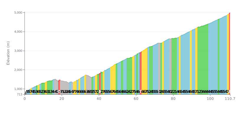
Difficulty breakdown: With 7068m of climbing over 110.7km, this ascent is extremely demanding, comparable to a queen stage of the Tour de France. The average gradient of 6.4% is sustained, but it's the length that makes the effort monumental. The profile is very uneven, alternating between sections at 9-11% and several significant descents (up to -7%), which breaks your rhythm.
Pacing tips:
1. Settle into a steady, controlled rhythm from the start to save energy for the long haul. Don't blow up in the first kilometres at 11%.
2. Make the most of the descents (like km 16-25) to recover actively by spinning lightly, without pushing, to loosen up your legs.
3. Prepare for the steep sections like km 62 (9%) or the finale (km 109-110.7 at 8%) so you can adjust your effort and stay in your endurance zone.
For riders who have tackled the Dongkha La, the experience is first defined by its exceptional and restricted nature. This pass, the fifth highest in India, is a place where civilians are rarely allowed, which makes the climb a unique, almost off-the-radar ride, under the protection of the Indian Army and the ITBP.
Riders' accounts describe breathtaking scenery, called "Heavenly Beautiful". The highlight is the view over Tso Lhamo Lake, the highest lake in India, and the chance to spot the Chinese mountains in the distance, giving a real sense of being at the end of the world.
The climb unfolds in a very particular setting, where the military presence is hard to miss. The future of this pass could be changed by road construction projects, but for now, the riders who have done it come away with memories of a pristine place and raw beauty.
110.7 km • 7068 m D+
VAM: average climbing speed, based on elevation gain


Join thousands of cycling fans! Plan your rides, record your performance, track your progress and discover the finest climbs.
Live climb profile to pace your effort all the way to the top.

