
Bemelerberg is a climb of 1.0 kilometers (category 4). The climb finishes at 122 m above sea level. It is located in Bemelen, Limburg, Nederland. The average gradient is 4.5% with a maximum of 7.6%. The climb has 44 meters of elevation gain.
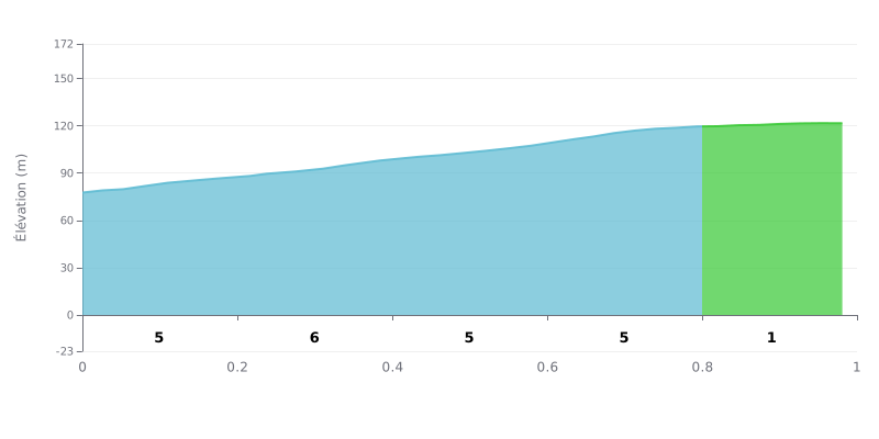
Difficulty analysis: With 1 km of climbing, 44 m of elevation gain and an average gradient of 4.5%, the Bemelerberg is rated Category 4. It's a short climb but a tough one, because the first 0.8 km hold a sustained gradient between 5% and 6% with no real respite. Only the last section, from 0.8 to 1.0 km, eases to 1% and offers a brief breather before the finish.
Tips for managing the effort:
1. Pace your start. In the first 200 m at 5%, keep a steady rhythm so you tackle the steepest section, 6% between 0.2 and 0.4 km, with composure.
2. Stay seated and stable. Between 0.4 and 0.8 km, the gradient stays constant at 5%, so remain seated in the saddle and keep a smooth cadence to save your legs.
3. Push on the final section. Between 0.8 and 1.0 km, the gradient drops to 1%: use it to gradually build speed and recover before you go for the finish.
On the Bemelerberg, most people walk it, but the cyclists who've climbed it find it steep and say you need good legs. Those who've been up it all say the climb is worth the detour.
What comes up most often is the sunken lane (holle weg) that climbs to the top, and the view over Bemelen and the surroundings. It's a quiet spot, mostly peace and quiet, and the nature is beautiful all year round. Several people also mention the sunset seen from the viewpoint.
On the practical side, plan ahead. Some people say the cafés and restaurants nearby aren't always open when you expect them to be, so it's best to check beforehand and book. The waymarking isn't always clear: one rider struggled to work out how to get through. Starting from the Poort van Maastricht campsite, you're quickly on the hill, with little elevation gain from that side, and the junction point network lets you build your own route. The viewpoint takes a small detour.
One negative point comes up repeatedly: access is restricted in the botanical heart of the site. One visitor regrets that Natuurmonumenten keeps people away from that area instead of letting them discover the nature, and feels the wildlife rest zones could be placed elsewhere.
A few reports also talk about the family atmosphere: the kids look for the little garden gnomes placed along the gnome trail (kabouter-pad). The Die Twie snack bar nearby is a good place to grab a bite and a drink while looking out over the landscape. For cycling enthusiasts, the Bemelerberg is also known as the climb from the Amstel Gold Race.
1.0 km • 44 m D+
VAM: average climbing speed, based on elevation gain


Join thousands of cycling fans! Plan your rides, record your performance, track your progress and discover the finest climbs.
Live climb profile to pace your effort all the way to the top.

