
Lutiška is a climb of 2.9 kilometers (category 3). The climb finishes at 672 m above sea level. It is located in Belá, Žilinský kraj, Slovensko. The average gradient is 5.8% with a maximum of 11.3%. The climb has 169 meters of elevation gain.
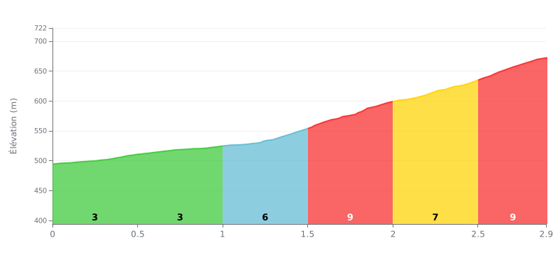
Difficulty breakdown: The Lutiška from Kociny is a 2.9 km climb averaging 5.8% for 169 m of elevation gain. The first two kilometres (0.0-1.0) at 3% are rolling and give you time to find your rhythm. The real work starts after that, with 6% between km 1.0 and 1.5, then 9% between 1.5 and 2.0, and 9% again between 2.5 and 2.9. That makes it a 3rd category climb that gets seriously hard in its second half.
Tips for managing the effort:
1. Save your legs at the start: over the first 1 km at 3%, ride at a steady pace and don't go out too hard, so you reach the 6% section with fresh legs.
2. Shift to an easier gear from km 1.5: on the 9% section between 1.5 and 2.0, drop into a light gear, keep a smooth, steady cadence and stay seated to maintain traction.
3. Save something for the finish: on the final 2.5 to 2.9 km at 9%, hold a constant cadence and a controlled breathing rhythm, and don't attack too early.
Those who've been over the Sedlo Lutiška mostly talk about the views over the Malá Fatra. Several find it a good spot to stop, take a break or just enjoy the quiet. One rider mentions the silence and the beautiful scenery, and another simply writes that it's a pleasant place.
The climb on the bike takes some effort. One cyclist describes it as demanding, doable from both sides, but he rates the one starting from Kubíkova as particularly tough. A loop is also mentioned: Varín, Terchová, the Lutišské sedlo, Horný Vadičov, Kotčina Lúčka, then back to Varín. Another rider describes the ride from Terchová towards Stará Bystrica as scenic.
The pass is also a starting point. Reports note that hiking and mountain bike trails start from here, and that it's easy to park the car and go for a walk. The place is described as well set up for believers.
The weak point comes up in one report: there's no water on site. You have to go down about 200 m following the yellow markers, heading east, to find some. If you're setting off without supplies, keep that in mind before the climb.
2.9 km • 169 m D+
VAM: average climbing speed, based on elevation gain


Join thousands of cycling fans! Plan your rides, record your performance, track your progress and discover the finest climbs.
Live climb profile to pace your effort all the way to the top.

