
Mount Darragh is a climb of 18.9 kilometers (hors catégorie). Mount Darragh tops out at 886 m above sea level. It is located in Bega Valley Shire Council, New South Wales, Australia. The average gradient is 3.9% with a maximum of 12.4%. The climb has 732 meters of elevation gain.
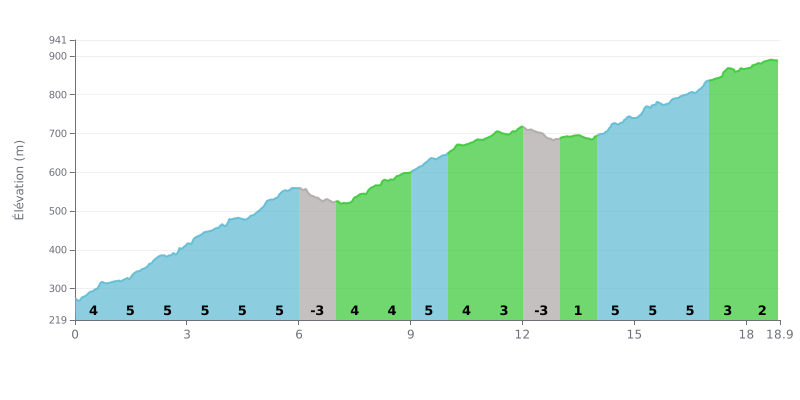
Difficulty analysis: This 18.9 km HC climb is moderate but sustained. The average gradient of 3.9% is steady over the first half (mostly 4-5%), with two short downhill sections (KM 6-7 and KM 12-13) and a flat section (KM 13-14) that give you welcome chances to recover. The last part (KM 14-18.9) demands a serious effort again (gradients of 4-5%) before a gentler finish.
Tips for pacing:
1. Managing your pace: Resist the urge to go too hard in the first kilometres at 5%. Use the downhill sections (KM 6-7 and KM 12-13) to ease off slightly and recover without losing your momentum.
2. Anticipating the sequences: The flat section at 1% (KM 13-14) is the ideal place to top up on food and fluids and prepare for the return to 4-5% gradients over the next four kilometres, which make up the last real test before the finish.
18.9 km • 732 m D+
VAM: average climbing speed, based on elevation gain


Join thousands of cycling fans! Plan your rides, record your performance, track your progress and discover the finest climbs.
Live climb profile to pace your effort all the way to the top.

