
Herlianske sedlo is a climb of 7.2 kilometers (category 3). The climb finishes at 661 m above sea level. It is located in Banské, Prešovský kraj, Slovensko. The average gradient is 4.9% with a maximum of 7.3%. The climb has 352 meters of elevation gain.
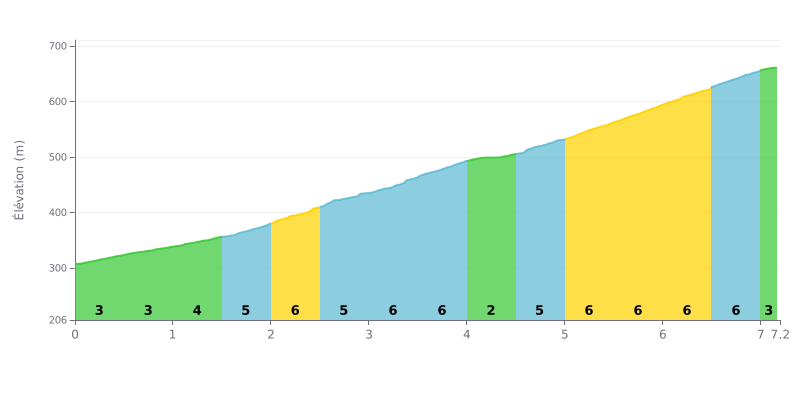
Difficulty analysis: With 7.2 km for 352 m of elevation gain and an average gradient of 4.9%, the Herlianske sedlo is a category 3 climb with a gradual start but a demanding finish. The first three kilometres at 3% let you settle in, before the road steepens between KM 1.5-2.0 and KM 3.5-4.0 with stretches at 5 and 6%. The real difficulty lies in the final section, from KM 5.0-5.5 to KM 6.5-7.0, where a near-constant 6% over two kilometres eats into your reserves, the KM 4.0-4.5 stretch at 3% offering only a brief respite.
Tips for managing the effort:
1. Set your pace from the start On the first three kilometres at 3%, ride at a steady cadence so you don't dig into your reserves before KM 5.0-5.5.
2. Make the most of the easier KM 4.0-4.5 section This 3% stretch is the chance to drink, take on food and get your breath back before the steepest part.
3. Handle the final 6% with consistency Between KM 5.0-5.5 and KM 6.5-7.0, stay seated, keep a stable cadence and avoid unnecessary surges so you reach the summit strong.
The Herlianske sedlo is often used as a starting point for the Slanské vrchy ridge. The car park is an improvised area next to a forest road. In summer there is room for quite a few cars. In winter you can park there as long as there isn't a metre of snow.
The climb from Herľany up to the pass is on brand-new asphalt, described as a great climb. On the Mošník side, a paved road runs through the forest. It is maintained because of the telecom equipment installed up there. The steepest sections hit 12%. The "road not maintained in winter" sign at the exit of Herľany doesn't match reality according to some riders, but after a fresh snowfall or a storm the road can quickly become impassable.
Those who have ridden it talk about a quiet spot. During one whole ride, a rider only passed ten people. Phone reception is practically non-existent, so it's best to let someone know before you head out.
The weak point comes up again and again: there is no shelter or bench at the top, even though one of the accounts says the writer took cover from the rain there. Above all, rubbish is a real problem. One witness collected 200 litres of rubbish near the trail marker and is clearly not happy about it.
7.2 km • 352 m D+
VAM: average climbing speed, based on elevation gain


Join thousands of cycling fans! Plan your rides, record your performance, track your progress and discover the finest climbs.
Live climb profile to pace your effort all the way to the top.

