
Banj Brdo is a climb of 3.7 kilometers (category 2). Banj Brdo tops out at 414 m above sea level. It is located in Banja Luka, Република Српска / Republika Srpska, Bosna i Hercegovina / Босна и Херцеговина. The average gradient is 6.9% with a maximum of 17.3%. The climb has 255 meters of elevation gain.
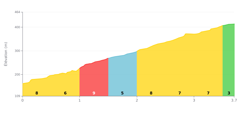
Difficulty breakdown: This Category 2 climb packs a demanding average gradient of 6.9% over 3.7 km. The real challenge is its consistency: six of the eight segments sit between 6% and 8%, so there's no meaningful respite. The flatter finish (3% over the last 200 meters) comes too late to change the overall nature of the effort.
Pacing advice:
1. Settle into a steady rhythm from the bottom: With the gradient fairly stable for most of the climb, avoid surges. Find a cadence and a power output you can hold quickly.
2. Prepare for the steepest section (KM 1.0-1.5 at 8%): Arrive at this kilometer with energy in reserve. Easing off your pace slightly before this stretch can help you avoid blowing up.
3. Use the easier final section to attack: The last 200m at 3% are your chance to up the cadence and finish strong without burying your legs.
Riders describe the climb up Banj brdo as an experience that blends effort and natural beauty. Two options are available: a paved road, or a trail that zigzags through the forest, a route riders appreciate for its scenery.
The reward at the top is unanimously praised: an incredible view and prelepa priroda (very beautiful nature) that makes the effort worth it. The atmosphere is described as full of pozitivna energija (positive energy), blending nature and history.
Riders' accounts describe a climb that can be teško (hard), but riders seem to enjoy the challenge. The descent, meanwhile, is rated najbolja (the best).
At the summit, riders find the little extra that feels great after the effort: the chance to grab an ice cream or a cold drink. For those hiking up on foot, the climb is estimated at around 45-60 minutes.
3.7 km • 255 m D+
VAM: average climbing speed, based on elevation gain


Join thousands of cycling fans! Plan your rides, record your performance, track your progress and discover the finest climbs.
Live climb profile to pace your effort all the way to the top.

