
Lainser ouguelid is a climb of 10.2 kilometers (category 1). Lainser ouguelid tops out at 732 m above sea level. It is located in Ath Chikh, Tizi Ouzou, Algérie ⵍⵣⵣⴰⵢⴻⵔ الجزائر. The average gradient is 5.6% with a maximum of 14.4%. The climb has 574 meters of elevation gain.
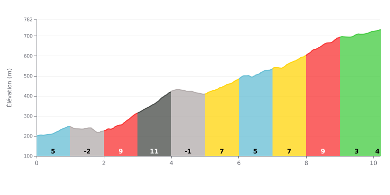
Difficulty breakdown: This first-category climb covers 10.2 km with 574 m of elevation gain, for an average gradient of 5.6%, making it a demanding and steady ascent. The real difficulty is in the middle section, especially between km 2 and km 4 where the gradient hits 9% then 11%, before a second tough stretch between km 8 and km 9 at 9%. The descents at km 1-2 and km 4-5 do offer some valuable breathing room. The finish, rolling at 3% then 4%, shouldn't make you forget the fatigue building up in your legs.
How to ride it:
1. Start conservatively On the first kilometer at 4%, settle into a steady rhythm so you don't burn through your legs before the heart of the climb.
2. Recover on the descents Use the descents at km 1-2 (-2%) and km 4-5 (-1%) to spin out your legs and top up your fluids without losing time.
3. Manage the central section Stay seated through the 9% and 11% sections between km 2 and km 4, in a gear that lets you spin comfortably, and save some energy for the 9% ramp between km 8 and km 9.
10.2 km • 574 m D+
VAM: average climbing speed, based on elevation gain


Join thousands of cycling fans! Plan your rides, record your performance, track your progress and discover the finest climbs.
Live climb profile to pace your effort all the way to the top.


Other climbs to Lainser ouguelid