
Portezuelo de Chapiquiña is a climb of 113.7 kilometers (hors catégorie). Portezuelo de Chapiquiña tops out at 4,446 m above sea level. It is located in Arica, Región de Arica y Parinacota, Chile. The average gradient is 4.2% with a maximum of 14.4%. The climb has 4778 meters of elevation gain.
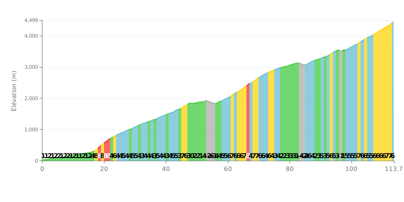
Difficulty analysis: This hors catégorie climb is extremely long (113.7 km) with a substantial elevation gain (4778 m). Its difficulty lies in its uneven profile. The first half (up to KM 50) alternates between false flats (1-2%) and steeper sections (4-9%), with even three kilometres of descent (KM 53 to 55). The second part is generally tougher, with many sustained sections between 5% and 9%, especially in the last 20 kilometres (gradients of 6-7%).
Pacing advice:
1. Managing your pace: Don't let the relatively gentle start fool you. Save your legs for the steeper second half. Use a power meter or a heart rate monitor to hold a steady effort, especially on the 8-9% ramps (KM 17-21).
2. Fuelling and hydration: The duration of the effort (several hours) is the main challenge. Plan your feeds in advance and drink regularly from the start to avoid dehydration and bonking.
3. Make the most of the recovery sections: The few kilometres of descent or easy gradient (KM 48-55) are crucial for recovering actively (spinning easy) and preparing for the hard sections that follow.
113.7 km • 4778 m D+
VAM: average climbing speed, based on elevation gain


Join thousands of cycling fans! Plan your rides, record your performance, track your progress and discover the finest climbs.
Live climb profile to pace your effort all the way to the top.

