
Abra Taapacà is a climb of 143.8 kilometers (hors catégorie). Abra Taapacà tops out at 4,777 m above sea level. It is located in Arica, Región de Arica y Parinacota, Chile. The average gradient is 4.0% with a maximum of 18.8%. The climb has 5743 meters of elevation gain.
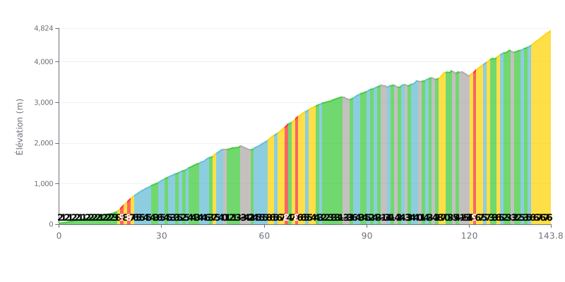
Difficulty breakdown: With 5743m of climbing over 143.8km, this ascent is extremely demanding. The 4% average gradient is misleading, because the profile shows some sharp variations. The toughest sections (8-9% pitches) are concentrated between km 17-25 and 121-123, with a sustained finish (6-7% over the last 10 km). The several descents (KM 53-56, 98-99, 109, 115, 118-119, 132) give you brief moments to recover.
Pacing advice:
1. Pace yourself from the start. This climb is very long, so hold a steady effort and spin a low cadence (70-80 rpm) on the moderate gradients (3-5%) to save your legs.
2. Prepare for the key sections. Ease off slightly before the 8-9% sections so you hit them with fresh legs. Use the descents to recover actively (soft pedalling) without pushing hard.
3. Manage your effort on the final push. The last part is hard, with gradients of 6% or more from KM 138. Save some energy for those last 5 km, which are particularly brutal.
For riders who have climbed it, the Taapaca ascent offers a breathtaking, mesmerizing view over the Chilean altiplano, a unique and hermoso landscape that stays with you.
The road, which lets you drive up to 5,000 m, isn't considered one of the hardest climbs, but riders report that it's still anstrengend (grueling). Proper acclimatization is crucial, otherwise the effort at altitude can turn dangerous.
The volcano, with its two craters and permanent glaciers, towers over the village of Putre and is visible from everywhere. Putre makes an ideal base camp, close to the start and offering tours to organize the climb.
In short, riders describe Taapaca as an exceptional place, a demanding experience that requires preparation but pays off with scenery that takes your breath away.
143.8 km • 5743 m D+
VAM: average climbing speed, based on elevation gain


Join thousands of cycling fans! Plan your rides, record your performance, track your progress and discover the finest climbs.
Live climb profile to pace your effort all the way to the top.

