
Majors Creek is a climb of 8.6 kilometers (hors catégorie). Majors Creek tops out at 702 m above sea level. It is located in Araluen, New South Wales, Australia. The average gradient is 6.4% with a maximum of 15.9%. The climb has 548 meters of elevation gain.
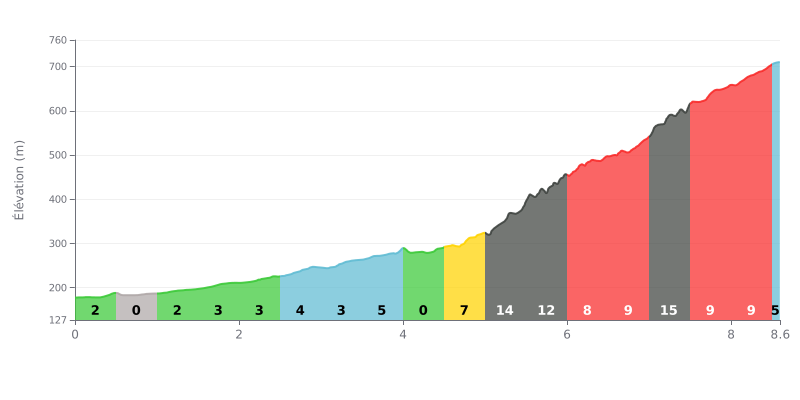
Difficulty breakdown: This 8.6 km climb is rated HC (beyond category) because of its 548m of elevation gain and an average gradient of 6%. The difficulty lies in its uneven pitch: the first 4 km are moderate (0-5%), but the gradient ramps up sharply after KM 4.5, with five sections over 9% and a brutal 15% spike between KM 7.0 and 7.5.
Pacing tips:
1. Managing your pace: Start easy over the first few kilometres, where the gradient is gentle, to save your legs. The real climbing begins after KM 4.5.
2. Prepare for the steep sections: Get ready mentally and physically for the very steep stretches (KM 5.0-6.0 and KM 7.0-7.5). Shift down to an easier gear in advance to keep your cadence up.
3. Active recovery: Use the short flat sections (KM 0.5-1.0 and KM 4.0-4.5) to briefly ease the pressure on your legs without stopping.
8.6 km • 548 m D+
VAM: average climbing speed, based on elevation gain


Join thousands of cycling fans! Plan your rides, record your performance, track your progress and discover the finest climbs.
Live climb profile to pace your effort all the way to the top.

