
Tizi n Tighist is a climb of 17.2 kilometers (hors catégorie). The climb finishes at 2,390 m above sea level. It is located in Aït Bou Oulli, Béni Mellal-Khénifra ⴰⵢⵜ ⵎⵍⵍⴰⵍ-ⵅⵏⵉⴼⵕⴰ بني ملال-خنيفرة, Maroc ⵍⵎⵖⵔⵉⴱ المغرب. The average gradient is 5.3% with a maximum of 13.3%. The climb has 916 meters of elevation gain.
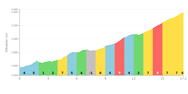
Difficulty breakdown: At 17.2 km, with 916 m of elevation gain and an average gradient of 5.3%, this climb is rated beyond category (HC) and demands a long, sustained effort. The hard part comes in the second half, with the 10% section between km 10 and 11, followed by 8% from km 14 to 15. Between km 13 and 17, the gradient stays steadily around 7%, with no respite, which takes its toll on the legs once fatigue builds up. Only km 2 to 3 (1%) and km 7 to 8 (-1%) give you any real chance to recover.
Pacing tips:
1. Pace yourself from the start. Ride conservatively in the first few kilometres and save something in the tank for the 10% ramp between km 10 and 11.
2. Make the most of the easy sections. Eat, drink and spin your legs over on the km 2 to 3 flat at 1%, and on the descent from km 7 to 8, because these breaks are rare.
3. Manage the finish. From km 13 to km 17, keep a smooth gear and a steady cadence, stay seated, and save your strength for the 8% section from km 14 to 15.
The Jbel Rat rock engravings are on the Tizi N'Tighist road, off the R307 between Aït Bouguemez and Demnate. Several riders say they spotted the sign by chance at a junction, then a ten-kilometre turn-off to the left from Aït Bouguemez, with no other signposting along the road.
On site, riders describe well-preserved engravings, some of which could date back more than 2,500 years BCE according to the museum. The small on-site museum, with panels and photos in French and Arabic, explains where the marks come from and how old they are. A caretaker or local guide shows visitors around, and several people mention Brahim and Abdel for their friendliness and their knowledge of the area. The view over the mountains comes up again and again, and one rider recommends coming at sunrise, when the engravings on the ground are lit up.
The climb itself is described as hard. One rider reckons it's only for those with a properly set-up bike and good fitness. The reports don't say much about the road surface, but the general feeling is captured by the word "grueling".
Several downsides are flagged. The area around the site is not maintained, and one rider regrets it. There is almost no water or resupply along the route, and the nearest villages have no shops or accommodation. Locals stock up in Sbit and Aït Bouwli. One account, written in English, stresses that the area is watched: there is a caretaker and dogs near the site, and a foreigner can be reported to the authorities. The writer advises setting out with water and food, and not heading off towards the villages unless properly equipped.
17.2 km • 916 m D+
VAM: average climbing speed, based on elevation gain


Join thousands of cycling fans! Plan your rides, record your performance, track your progress and discover the finest climbs.
Live climb profile to pace your effort all the way to the top.

