
Tunnel de Salang is a climb of 39.3 kilometers (hors catégorie). Tunnel de Salang tops out at 3,389 m above sea level. It is located in Ahangaran, ولایت بغلان, افغانستان. The average gradient is 6.1% with a maximum of 16.5%. The climb has 2410 meters of elevation gain.
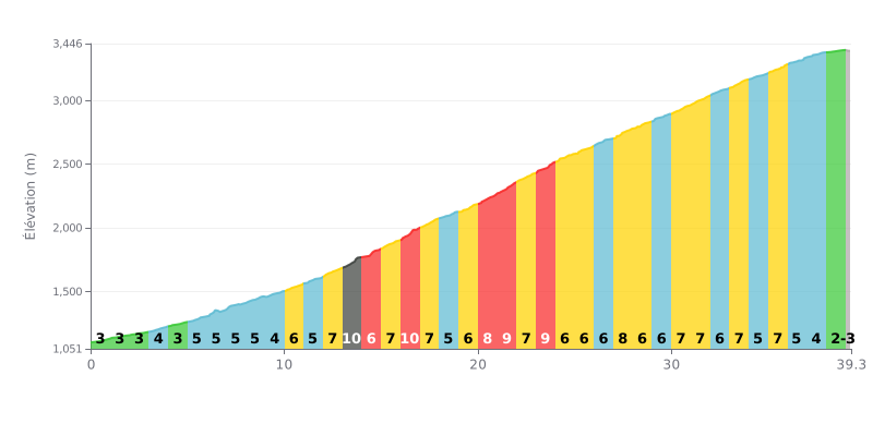
Difficulty analysis: At 39.3 km averaging 6.1%, the Chokak climb is a long, beyond-category endurance test. The difficulty lies in its demanding consistency, with most kilometres between 6% and 7%, punctuated by steeper sections (notably stretches at 9% and 10% between km 14 and 23) that really take it out of your legs.
Tips for managing the effort:
1. Pace yourself from the start: The first kilometres (3-4%) are deceptive. Don't go over the top early, so you have something left in the tank for the harder middle section.
2. Anticipate the steep sections: Mentally mark the steepest kilometres (14-16, 20-23) and ease off the pace slightly before you reach them to keep your cadence steady.
3. Make the most of the easier finish: The final kilometres (after km 34) are less steep. Use this section to recover a bit and finish strong.
39.3 km • 2410 m D+
VAM: average climbing speed, based on elevation gain


Join thousands of cycling fans! Plan your rides, record your performance, track your progress and discover the finest climbs.
Live climb profile to pace your effort all the way to the top.

