
Vratnik pass is a climb of 13.1 kilometers (category 1). Vratnik pass tops out at 922 m above sea level. It is located in Бяла, Сливен, България. The average gradient is 3.5% with a maximum of 10.6%. The climb has 455 meters of elevation gain.
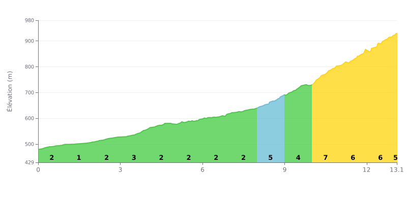
Difficulty breakdown: This Cat 1 climb has a two-part profile. The first 8 km are moderate (average gradient of 2%), a long warm-up. The real difficulty is concentrated in the last 5 km, where the gradient ramps up sharply to 6-7%, accounting for nearly half of the total elevation gain.
Pacing advice:
1. Managing your pace on the first section: Resist the temptation to go too hard on the gentle early slopes so you save your legs for later.
2. Anticipating the change in rhythm: From the 8th km onward, get ready mentally and physically for the steepening gradient (5%, then 6-7%) by shifting into an easier gear.
3. Focusing on the final kilometres: The decisive effort comes between km 10 and 13. Hold a steady cadence so you don't blow up on this most demanding section.
Cyclists who have climbed the Vratnik pass describe a road with two faces. On one side, a section has a fresh layer of asphalt, with enjoyable bends that, according to their experience, make for a real pleasure on the bike. On the other, several riders clearly report that some stretches are not maintained, with a surface riddled with potholes.
The atmosphere up there is something special. Riders report a feeling of calm and serenity, a quiet spot where you won't find a café or any accommodation. This stillness contrasts with the both magnificent and intimidating character of the place, with some even describing a certain sense of awe bordering on fear in the face of the scenery.
The climb is also a journey through history. Riders mention the proximity of Agilikina Polyana, a historic site where the haiduks used to gather, adding a fascinating dimension to the ascent.
In the end, the riders' experience is that of an authentic, raw climb. It rewards you with its beauty and its calm, but it doesn't hide its challenges, such as the degraded road surfaces, which demand constant attention.
13.1 km • 455 m D+
VAM: average climbing speed, based on elevation gain


Join thousands of cycling fans! Plan your rides, record your performance, track your progress and discover the finest climbs.
Live climb profile to pace your effort all the way to the top.

