
Vigla is a climb of 16.4 kilometers (hors catégorie). Vigla tops out at 1,543 m above sea level. It is located in Φλώρινα, Αποκεντρωμένη Διοίκηση Ηπείρου - Δυτικής Μακεδονίας, Ελλάς. The average gradient is 5.3% with a maximum of 12.8%. The climb has 868 meters of elevation gain.
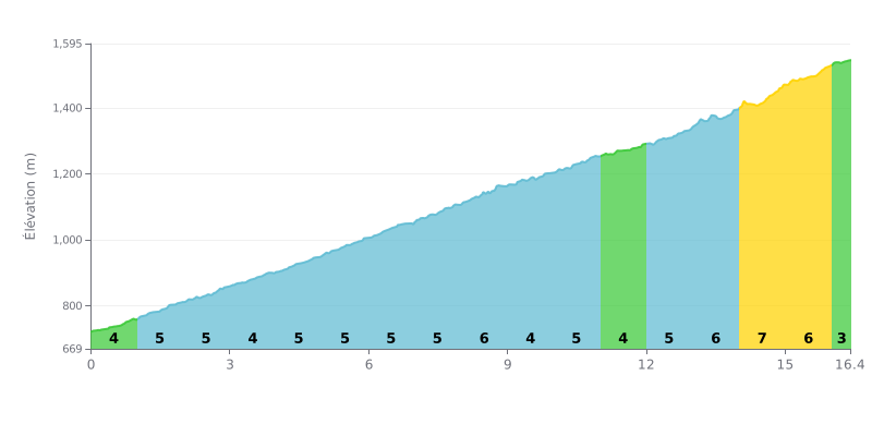
Difficulty breakdown: This 16.4 km beyond-category climb is sustained but steady over the first two-thirds, with an average gradient of 5%. The difficulty ramps up significantly over the last 3 km, where the gradient kicks up to 6 to 7%, making it the hardest section.
Tips for the effort:
1. Pacing: Hold a steady power output over the first 13 km to save your legs for the steeper finale.
2. Save something for the end: Keep some effort in reserve for kilometres 14 to 15 (7% gradient), the steepest part of the climb.
3. Active recovery: Use the last section (16.0-16.4 km at 3%) to ease off slightly before the summit.
16.4 km • 868 m D+
VAM: average climbing speed, based on elevation gain


Join thousands of cycling fans! Plan your rides, record your performance, track your progress and discover the finest climbs.
Live climb profile to pace your effort all the way to the top.

