
Vaslitsa is a climb of 16.2 kilometers (hors catégorie). Vaslitsa tops out at 1,773 m above sea level. It is located in Δήμος Κόνιτσας, Αποκεντρωμένη Διοίκηση Ηπείρου - Δυτικής Μακεδονίας, Ελλάς. The average gradient is 6.4% with a maximum of 12.8%. The climb has 1043 meters of elevation gain.
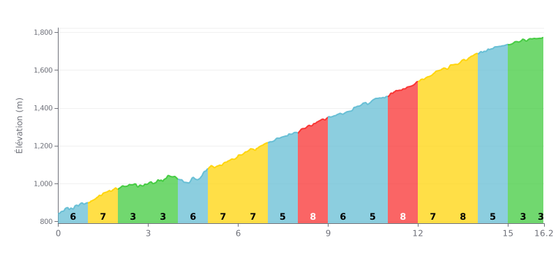
Difficulty analysis: A demanding hors catégorie climb over 16.2 km. The 6.4% average gradient is deceptive: the profile is very uneven, with steep sections (7-8% gradients on KM 8-9 and 11-14) broken up by easier stretches (KM 2-4 and the final part). The difficulty lies in that variation and the total length.
Pacing advice:
1. Pace yourself from the start: The first kilometres (6-7%) are tempting to attack. Don't go over the top before the easier sections (KM 2-4 at 2-3%), where you can recover.
2. Plan for the key sections: The toughest stretches (8%) come between KM 8-9 and 11-14. Save something for these segments by holding a steady tempo on the 5-6% gradients leading into them.
3. Use the finish to kick on: The last kilometres (KM 15-16.2 at 3%) are less steep. If you've paced the effort well, this section lets you raise the tempo before the finish.
16.2 km • 1043 m D+
VAM: average climbing speed, based on elevation gain


Join thousands of cycling fans! Plan your rides, record your performance, track your progress and discover the finest climbs.
Live climb profile to pace your effort all the way to the top.


Other climbs to Vaslitsa